
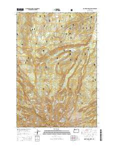
~ Mount Hood North OR topo map, 1:24000 scale, 7.5 X 7.5 Minute, Current, 2014
Mount Hood North, Oregon, USGS topographic map dated 2014.
Includes geographic coordinates (latitude and longitude). This topographic map is suitable for hiking, camping, and exploring, or framing it as a wall map.
Printed on-demand using high resolution imagery, on heavy weight and acid free paper, or alternatively on a variety of synthetic materials.
Topos available on paper, Waterproof, Poly, or Tyvek. Usually shipping rolled, unless combined with other folded maps in one order.
- Product Number: USGS-7253458
- Free digital map download (high-resolution, GeoPDF): Mount Hood North, Oregon (file size: 38 MB)
- Map Size: please refer to the dimensions of the GeoPDF map above
- Weight (paper map): ca. 55 grams
- Map Type: POD USGS Topographic Map
- Map Series: US Topo
- Map Verison: Current
- Cell ID: 30637
- Datum: North American Datum of 1983
- Map Projection: Transverse Mercator
- Map Cell Name: Mount Hood North
- Grid size: 7.5 X 7.5 Minute
- Date on map: 2014
- Map Scale: 1:24000
- Geographical region: Oregon, United States
Neighboring Maps:
All neighboring USGS topo maps are available for sale online at a variety of scales.
Spatial coverage:
Topo map Mount Hood North, Oregon, covers the geographical area associated the following places:
- Pulpit Rock - Inspiration Point - Ghost Ridge - Vista Ridge Trail - Langille Glacier - Tilly Jane Trail - Wallalute Falls - Cloud Cap Saddle Recreation Site - Elk Cove - Recession Lakes - Pinnacle Creek - Wy'east Basin - Kinnikinnick Recreation Site - Timberline Trail - Red Hill - File Butte - The Pinnacle - Cathedral Ridge - Pinnacle Ridge Trail - Bear Creek - Sandy Glacier - Tilly Jane Guard Station - Glisan Glacier - Perry Lake - McNeil Point - Boomer Creek - Laurance Lake Boat Ramp - Squeegee Creek - Dollar Quarry - Eliot Branch - Reservoir Campground - Cairn Basin - Eden Park - Laurance Lake - Langille Crags - Yocum Ridge - Tilly Jane Recreation Site - Cloud Cap-Tilly Jane Historic Area - Stranahan Ridge - Stump Creek Trail - Barrett Spur - Compass Creek - Elk Grove Trail - Vista Ridge - Cooper Spur Ski Trail - Clear Branch - Dollar Lake - Coe Branch - Coe Glacier - Clear Branch Dam - Cloud Cap Inn - Eliot Glacier - Cooper Spur - Ladd Glacier - Sandy Glacier Headwall - Red Hill Guard Station
- Map Area ID: AREA45.545.375-121.75-121.625
- Northwest corner Lat/Long code: USGSNW45.5-121.75
- Northeast corner Lat/Long code: USGSNE45.5-121.625
- Southwest corner Lat/Long code: USGSSW45.375-121.75
- Southeast corner Lat/Long code: USGSSE45.375-121.625
- Northern map edge Latitude: 45.5
- Southern map edge Latitude: 45.375
- Western map edge Longitude: -121.75
- Eastern map edge Longitude: -121.625


