
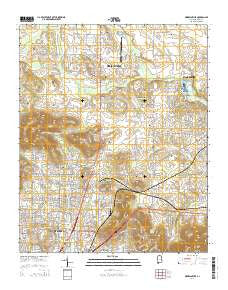
~ Meridianville AL topo map, 1:24000 scale, 7.5 X 7.5 Minute, 2014
Meridianville, Alabama, USGS topographic map dated 2014.
Includes geographic coordinates (latitude and longitude). This topographic map is suitable for hiking, camping, and exploring, or framing it as a wall map.
Printed on-demand using high resolution imagery, on heavy weight and acid free paper, or alternatively on a variety of synthetic materials.
Topos available on paper, Waterproof, Poly, or Tyvek. Usually shipping rolled, unless combined with other folded maps in one order.
- Product Number: USGS-7244161
- Free digital map download (high-resolution, GeoPDF): Meridianville, Alabama (file size: 25 MB)
- Map Size: please refer to the dimensions of the GeoPDF map above
- Weight (paper map): ca. 55 grams
- Map Type: POD USGS Topographic Map
- Map Series: US Topo
- Map Verison: Current
- Cell ID: 28846
- Datum: North American Datum of 1983
- Map Projection: Transverse Mercator
- Map Cell Name: Meridianville
- Grid size: 7.5 X 7.5 Minute
- Date on map: 2014
- Map Scale: 1:24000
- Geographical region: Alabama, United States
Neighboring Maps:
All neighboring USGS topo maps are available for sale online at a variety of scales.
Spatial coverage:
Topo map Meridianville, Alabama, covers the geographical area associated the following places:
- Mountain Springs Estates - Lakewood Manor - Meadow Lane Estates - Ashland - Glen Park - Cherry Creek - Davis Hills - The Woodlands - Mercury - Blue Spring Garden - Brookhurst - Baltimore Hill - Windsor Manor - Scenic View - Greenhill - Edmonton Heights - Davis Hills Estates - Mount Charron Estates - Valley Park - Country Village - Chase - Kildere Estates - Grove View Acres - Cedar Valley - Normal - Lakewood - Moores Mill - Lincoya - Country Club Estates - Colonial Gardens - Mount Lebanon - Meridianville - Edgemont - Valley View Estates - Chapman Heights - Pearsall Gardens - Eastridge - Meadow Hills - Shady Lane - Stag Run - Bellemeade - Cedargate - Colonial Hills - Pleasant Acres - Cherokee Hills
- Map Area ID: AREA34.87534.75-86.625-86.5
- Northwest corner Lat/Long code: USGSNW34.875-86.625
- Northeast corner Lat/Long code: USGSNE34.875-86.5
- Southwest corner Lat/Long code: USGSSW34.75-86.625
- Southeast corner Lat/Long code: USGSSE34.75-86.5
- Northern map edge Latitude: 34.875
- Southern map edge Latitude: 34.75
- Western map edge Longitude: -86.625
- Eastern map edge Longitude: -86.5


