
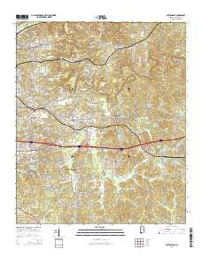
~ Cottondale AL topo map, 1:24000 scale, 7.5 X 7.5 Minute, 2014
Cottondale, Alabama, USGS topographic map dated 2014.
Includes geographic coordinates (latitude and longitude). This topographic map is suitable for hiking, camping, and exploring, or framing it as a wall map.
Printed on-demand using high resolution imagery, on heavy weight and acid free paper, or alternatively on a variety of synthetic materials.
Topos available on paper, Waterproof, Poly, or Tyvek. Usually shipping rolled, unless combined with other folded maps in one order.
- Product Number: USGS-7243373
- Free digital map download (high-resolution, GeoPDF): Cottondale, Alabama (file size: 29 MB)
- Map Size: please refer to the dimensions of the GeoPDF map above
- Weight (paper map): ca. 55 grams
- Map Type: POD USGS Topographic Map
- Map Series: US Topo
- Map Verison: Current
- Cell ID: 10270
- Datum: North American Datum of 1983
- Map Projection: Transverse Mercator
- Map Cell Name: Cottondale
- Grid size: 7.5 X 7.5 Minute
- Date on map: 2014
- Map Scale: 1:24000
- Geographical region: Alabama, United States
Neighboring Maps:
All neighboring USGS topo maps are available for sale online at a variety of scales.
Spatial coverage:
Topo map Cottondale, Alabama, covers the geographical area associated the following places:
- Green Grove - Claymont - Sherwood Forest - Briarwood - Lavelle Woods - Hillswood - Cumberland Park - Standridge - Asbury - Peterson - South Holt - Beech Hills - High Point - Woodland Park - Banks Villa East - Woodmont - Judson Park - Arrow Wood - Eastover - Berkley Hills - East Lake - Cherrywood - Clearview Hills - Laurel Hills - Oxford Gate - Clyde Jones Subdivision - Cottonwood Park - Arcadia - Box Springs - Woodland Hills - Holt - Norris Estates - Fleetwood - Huntland - Lynn Haven - Kyles Subdivision - Walker Subdivision - Norris Circle - Forestasia - Golden Acres - Grimes - Hurricane Hills - Whispering Hills - East Park - Cadillac Estates - Cottondale - Hillview - Westview - Deep Wood - Mayfair - Woodland Forest - Alpine Hills - Springhill Lake - Druid Hills - South Holt Highlands - Oak Grove - Cresent Heights - Keenewood - Colony Hills - Summerfield - Monte Vista - Hazelhurst - Woodland Terrace - Woodland Pines - Eastern Hills - Brentwood - Canyon Lakes - Glenwood Park - Altamont - Windsor Drive - Old Mill Trace - Elm Ridge - Three Branches Estates - Austin Subdivision - El Dorado East - Hillsdale - Broadview - Nichol Hills - The Staffords - Peach Grove - Poes Acres
- Map Area ID: AREA33.2533.125-87.5-87.375
- Northwest corner Lat/Long code: USGSNW33.25-87.5
- Northeast corner Lat/Long code: USGSNE33.25-87.375
- Southwest corner Lat/Long code: USGSSW33.125-87.5
- Southeast corner Lat/Long code: USGSSE33.125-87.375
- Northern map edge Latitude: 33.25
- Southern map edge Latitude: 33.125
- Western map edge Longitude: -87.5
- Eastern map edge Longitude: -87.375


