
~ Garland Prairie AZ topo map, 1:24000 scale, 7.5 X 7.5 Minute, 2014
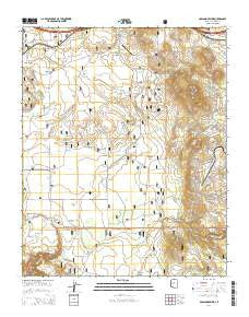
Garland Prairie, Arizona, USGS topographic map dated 2014.
Includes geographic coordinates (latitude and longitude). This topographic map is suitable for hiking, camping, and exploring, or framing it as a wall map.
Printed on-demand using high resolution imagery, on heavy weight and acid free paper, or alternatively on a variety of synthetic materials.
Topos available on paper, Waterproof, Poly, or Tyvek. Usually shipping rolled, unless combined with other folded maps in one order.
- Product Number: USGS-7240269
- Free digital map download (high-resolution, GeoPDF): Garland Prairie, Arizona (file size: 26 MB)
- Map Size: please refer to the dimensions of the GeoPDF map above
- Weight (paper map): ca. 55 grams
- Map Type: POD USGS Topographic Map
- Map Series: US Topo
- Map Verison: Current
- Cell ID: 16865
- Datum: North American Datum of 1983
- Map Projection: Transverse Mercator
- Map Cell Name: Garland Prairie
- Grid size: 7.5 X 7.5 Minute
- Date on map: 2014
- Map Scale: 1:24000
- Geographical region: Arizona, United States
Neighboring Maps:
All neighboring USGS topo maps are available for sale online at a variety of scales.
Spatial coverage:
Topo map Garland Prairie, Arizona, covers the geographical area associated the following places:
- Gray Tank - Garland Prairie Tank - Manterola Tank - Garland Spring - Upper Hull Spring - Horse Lake - Montezuma Tank - Mickle Tank - Alive Tank - Aso Number Two Tank - Long Park - McDermit Canyon - Corsair Tank - Rybery Tank - Mooney Mountain - Mineral Spring - Raymond Pit - Sawmill Tank - Robin Tank - Ramon Tank - Lower Hull Spring - Dow Spring - Pitman Valley - Garjon Tank - Sunrise Ranch Airport - Gray Spring - Horse Tank - Volunteer Tank - Dutch Kid Tank - Railroad Spring - Stump Tank - Blue Tank - Camp Navajo - Little Joe Tank - Poison Spring - Kilgore Tank - Boynton Tank - Power Line Tank - Long Park Tank - Garland Prairie - Volunteer Mountain - Spitz Spring Underpass - Triangle Spring - Wright Tanks - Sheep Tank - Mustang Tank - Green Tank - Johnson Tank - Bankhead Tank - Morgan Tank - Toy Tank - Allan Tank - Horse Lake Tank - Great Dane Tank - L O Spring - Powerline Tank - Spitz Spring Overpass
- Map Area ID: AREA35.2535.125-112-111.875
- Northwest corner Lat/Long code: USGSNW35.25-112
- Northeast corner Lat/Long code: USGSNE35.25-111.875
- Southwest corner Lat/Long code: USGSSW35.125-112
- Southeast corner Lat/Long code: USGSSE35.125-111.875
- Northern map edge Latitude: 35.25
- Southern map edge Latitude: 35.125
- Western map edge Longitude: -112
- Eastern map edge Longitude: -111.875


