
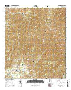
~ Chiricahua Peak AZ topo map, 1:24000 scale, 7.5 X 7.5 Minute, 2014
Chiricahua Peak, Arizona, USGS topographic map dated 2014.
Includes geographic coordinates (latitude and longitude). This topographic map is suitable for hiking, camping, and exploring, or framing it as a wall map.
Printed on-demand using high resolution imagery, on heavy weight and acid free paper, or alternatively on a variety of synthetic materials.
Topos available on paper, Waterproof, Poly, or Tyvek. Usually shipping rolled, unless combined with other folded maps in one order.
- Product Number: USGS-7236431
- Free digital map download (high-resolution, GeoPDF): Chiricahua Peak, Arizona (file size: 31 MB)
- Map Size: please refer to the dimensions of the GeoPDF map above
- Weight (paper map): ca. 55 grams
- Map Type: POD USGS Topographic Map
- Map Series: US Topo
- Map Verison: Current
- Cell ID: 8614
- Datum: North American Datum of 1983
- Map Projection: Transverse Mercator
- Map Cell Name: Chiricahua Peak
- Grid size: 7.5 X 7.5 Minute
- Date on map: 2014
- Map Scale: 1:24000
- Geographical region: Arizona, United States
Neighboring Maps:
All neighboring USGS topo maps are available for sale online at a variety of scales.
Spatial coverage:
Topo map Chiricahua Peak, Arizona, covers the geographical area associated the following places:
- Sycamore Canyon - Turkey Pen Canyon - Pole Bridge Trail Two Hundred Sixtyfour - Monte Vista Peak - Coal Pit Tank - North Ward Canyon - Round Park - Brushy Canyon - Coronado National Forest - Pole Bridge Canyon Natural Area - Hermitage Forest Camp - Red Rock Canyon - Turkey Creek Ranger Station - Mormon Ridge Trail Two Hundred Sixtynine - Douglas Ranger District - Price Spring - Rucker Canyon Dam - Morse Canyon Campground - Bear Canyon - Lone Juniper Spring - West Turkey Creek Campground - Dobson Peak - Deer Spring - Cottonwood Creek - Cima Park - Rucker Canyon Trail Two Hundred Twentytwo - Sanders Peak - Cypress Forest Camp - Anita Spring - Cima Saddle - Junction Saddle - Bear Spring - Brushy Creek - Erickson Peak - Cottonwood Canyon Trail Two Hundred Sixtysix - Buckskin Saddle - Sycamore Spring - Eagle Spring - Cottonwood Spring - Flys Peak - Baker Canyon - Juniper Spring - Chiricahua Wilderness - Raspberry Ridge - Crest Trail Two Hundred Seventy - North Fork Rucker Canyon - Bathtub Forest Camp - Cummings Tank - Turtle Mountain Trail Two Hundred Nineteen - Rucker Forest Camp - Mormon Spring - Cima Ranger Station - Pole Bridge Canyon - Ward Canyon - Rucker Lake Campground - Raspberry Peak - Turtle Mountain - Morse Canyon - Paint Rock - Sage Peak - Camp Rucker Campground - Price Canyon Trail Two Hundred Twentyfour - Saulsbury Canyon - Turkey Creek Campground - Chiricahua Peak - Walnut Grove Campground - Snowshed Peak - Winn Falls - Booger Spring - Rucker Ranger Station - Rucker Lake - Rucker Canyon Ranch - Rucker Raspberry Ridge Trail Two Hundred Twentyeight - Anita Park - Black Mountain
- Map Area ID: AREA31.87531.75-109.375-109.25
- Northwest corner Lat/Long code: USGSNW31.875-109.375
- Northeast corner Lat/Long code: USGSNE31.875-109.25
- Southwest corner Lat/Long code: USGSSW31.75-109.375
- Southeast corner Lat/Long code: USGSSE31.75-109.25
- Northern map edge Latitude: 31.875
- Southern map edge Latitude: 31.75
- Western map edge Longitude: -109.375
- Eastern map edge Longitude: -109.25


