
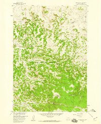
~ Badger Peak MT topo map, 1:24000 scale, 7.5 X 7.5 Minute, Historical, 1958, updated 1960
Badger Peak, Montana, USGS topographic map dated 1958.
Includes geographic coordinates (latitude and longitude). This topographic map is suitable for hiking, camping, and exploring, or framing it as a wall map.
Printed on-demand using high resolution imagery, on heavy weight and acid free paper, or alternatively on a variety of synthetic materials.
Topos available on paper, Waterproof, Poly, or Tyvek. Usually shipping rolled, unless combined with other folded maps in one order.
- Product Number: USGS-6009141
- Free digital map download (high-resolution, GeoPDF): Badger Peak, Montana (file size: 15 MB)
- Map Size: please refer to the dimensions of the GeoPDF map above
- Weight (paper map): ca. 55 grams
- Map Type: POD USGS Topographic Map
- Map Series: HTMC
- Map Verison: Historical
- Cell ID: 2097
- Scan ID: 262218
- Imprint Year: 1960
- Woodland Tint: Yes
- Aerial Photo Year: 1956
- Field Check Year: 1958
- Datum: NAD27
- Map Projection: Polyconic
- Map published by United States Geological Survey
- Map Language: English
- Scanner Resolution: 600 dpi
- Map Cell Name: Badger Peak
- Grid size: 7.5 X 7.5 Minute
- Date on map: 1958
- Map Scale: 1:24000
- Geographical region: Montana, United States
Neighboring Maps:
All neighboring USGS topo maps are available for sale online at a variety of scales.
Spatial coverage:
Topo map Badger Peak, Montana, covers the geographical area associated the following places:
- 02S41E12ABD_01 Well - Diamond R Spring - Mud Draw - 02S42E01BBBC01 Well - Wood Spring - Badger Peak - 01S42E35CBBC01 Well - 01S42E27CBBC01 Well - 02S42E30CCB_01 Well - 02S42E27ABA_01 Well - 02S42E03BDCD01 Spring - Kelly Creek - West Fork Ryegrass Creek - 02S42E02BDCA01 Well - 02S42E18BCA_01 Well - 08S42E21AAAC01 Spring - 02S42E30CBA_01 Well - 02S42E04ADCB01 Spring - South Fork Alderson Creek - West Fork Miller Creek - 01S42E23CDCA01 Well - 01S42E26DBDA01 Well - 01S42E34AADA01 Well - 01S42E26DBAB01 Spring - Charlie Black Butte - Mud Springs
- Map Area ID: AREA45.7545.625-106.625-106.5
- Northwest corner Lat/Long code: USGSNW45.75-106.625
- Northeast corner Lat/Long code: USGSNE45.75-106.5
- Southwest corner Lat/Long code: USGSSW45.625-106.625
- Southeast corner Lat/Long code: USGSSE45.625-106.5
- Northern map edge Latitude: 45.75
- Southern map edge Latitude: 45.625
- Western map edge Longitude: -106.625
- Eastern map edge Longitude: -106.5


