
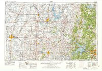
~ Enid OK topo map, 1:250000 scale, 1 X 2 Degree, Historical, 1955, updated 1978
Enid, Oklahoma, USGS topographic map dated 1955.
Includes geographic coordinates (latitude and longitude). This topographic map is suitable for hiking, camping, and exploring, or framing it as a wall map.
Printed on-demand using high resolution imagery, on heavy weight and acid free paper, or alternatively on a variety of synthetic materials.
Topos available on paper, Waterproof, Poly, or Tyvek. Usually shipping rolled, unless combined with other folded maps in one order.
- Product Number: USGS-6006974
- Free digital map download (high-resolution, GeoPDF): Enid, Oklahoma (file size: 13 MB)
- Map Size: please refer to the dimensions of the GeoPDF map above
- Weight (paper map): ca. 55 grams
- Map Type: POD USGS Topographic Map
- Map Series: HTMC
- Map Verison: Historical
- Cell ID: 68769
- Scan ID: 802248
- Imprint Year: 1978
- Woodland Tint: Yes
- Aerial Photo Year: 1976
- Edit Year: 1978
- Field Check Year: 1955
- Datum: Unstated
- Map Projection: Transverse Mercator
- Map published by United States Geological Survey
- Map Language: English
- Scanner Resolution: 508 dpi
- Map Cell Name: Enid
- Grid size: 1 X 2 Degree
- Date on map: 1955
- Map Scale: 1:250000
- Geographical region: Oklahoma, United States
Neighboring Maps:
All neighboring USGS topo maps are available for sale online at a variety of scales.
Spatial coverage:
Topo map Enid, Oklahoma, covers the geographical area associated the following places:
- Gibbon - Frankfort - Gray - Bowden - Autwine - Osage - Petes Corner - Tallant - Gray Horse - Olive - Sand Springs - Jubys - Yost - Pond Creek - Lucien - Marland - Middleton - Fairmont - Sumpter - Kremlin - Fite - Oak Ridge - New Prue - Pemeta - Foraker - Eddy - Jennings - Bison - Mehan - Jefferson - Covington - Hallett - Lawrence Creek - Oakridge - Prattville - Schlegel - Imo - Remington - West Tulsa - Shirk - Kaw Agency (historical) - Masham - Carbondale - Yale - Kaw City - Calida - Clyde - Boulanger Landing - Ingalls - Oak Grove - Hominy - Salt Fork - Breckinridge - Casey - Wakita - Lep - Washunga - Kiheki - Nelagoney - Stillwater - Blackburn - Cleveland - Rabornville - Woolaroc - Grainville - Cropper - Apperson - Medford - Cody - Quay - Hardy - Gilbert - McCord - Little Chief - Leroy - Douglas - Ripley - Watchorn - Etna - Soldani - Garber - Mule Barn - Grainola - Opah - Lyman - Herd - Burbank - Jacks - Tyner - Ponca City - Hickory Hill - Skiatook - Garden City - Wolco - Marshall - Terlton - Ceres - Fairfax - Hennessey - Gilland
- Map Area ID: AREA3736-98-96
- Northwest corner Lat/Long code: USGSNW37-98
- Northeast corner Lat/Long code: USGSNE37-96
- Southwest corner Lat/Long code: USGSSW36-98
- Southeast corner Lat/Long code: USGSSE36-96
- Northern map edge Latitude: 37
- Southern map edge Latitude: 36
- Western map edge Longitude: -98
- Eastern map edge Longitude: -96


