
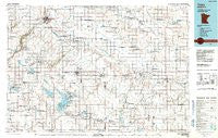
~ Tracy MN topo map, 1:100000 scale, 30 X 60 Minute, Historical, 1986, updated 1991
Tracy, Minnesota, USGS topographic map dated 1986.
Includes geographic coordinates (latitude and longitude). This topographic map is suitable for hiking, camping, and exploring, or framing it as a wall map.
Printed on-demand using high resolution imagery, on heavy weight and acid free paper, or alternatively on a variety of synthetic materials.
Topos available on paper, Waterproof, Poly, or Tyvek. Usually shipping rolled, unless combined with other folded maps in one order.
- Product Number: USGS-5989208
- Free digital map download (high-resolution, GeoPDF): Tracy, Minnesota (file size: 14 MB)
- Map Size: please refer to the dimensions of the GeoPDF map above
- Weight (paper map): ca. 55 grams
- Map Type: POD USGS Topographic Map
- Map Series: HTMC
- Map Verison: Historical
- Cell ID: 68475
- Scan ID: 508828
- Imprint Year: 1991
- Woodland Tint: Yes
- Aerial Photo Year: 1984
- Edit Year: 1986
- Datum: NAD27
- Map Projection: Universal Transverse Mercator
- Map published by United States Geological Survey
- Map Language: English
- Scanner Resolution: 508 dpi
- Map Cell Name: Tracy
- Grid size: 30 X 60 Minute
- Date on map: 1986
- Map Scale: 1:100000
- Geographical region: Minnesota, United States
Neighboring Maps:
All neighboring USGS topo maps are available for sale online at a variety of scales.
Spatial coverage:
Topo map Tracy, Minnesota, covers the geographical area associated the following places:
- Rowena - Storden - Burchard - Lamberton - Lucan - Garvin Park - Russell - Amiret - The Lakes - Revere - Clements - Marshall - Sanborn - Seaforth - Dudley - Wanda - Wabasso - Milroy - Currie - Current Lake - Walnut Grove - Lynd - Dovray - Tracy - Lynd Mobile Home Park - Garvin - Balaton - Lowville - Hadley - Village Park - Westbrook - Cedar Lane Trailer Park - Owanka - Jeffers
- Map Area ID: AREA44.544-96-95
- Northwest corner Lat/Long code: USGSNW44.5-96
- Northeast corner Lat/Long code: USGSNE44.5-95
- Southwest corner Lat/Long code: USGSSW44-96
- Southeast corner Lat/Long code: USGSSE44-95
- Northern map edge Latitude: 44.5
- Southern map edge Latitude: 44
- Western map edge Longitude: -96
- Eastern map edge Longitude: -95


