
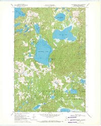
~ Strawberry Lake MN topo map, 1:24000 scale, 7.5 X 7.5 Minute, Historical, 1969, updated 1971
Strawberry Lake, Minnesota, USGS topographic map dated 1969.
Includes geographic coordinates (latitude and longitude). This topographic map is suitable for hiking, camping, and exploring, or framing it as a wall map.
Printed on-demand using high resolution imagery, on heavy weight and acid free paper, or alternatively on a variety of synthetic materials.
Topos available on paper, Waterproof, Poly, or Tyvek. Usually shipping rolled, unless combined with other folded maps in one order.
- Product Number: USGS-5989026
- Free digital map download (high-resolution, GeoPDF): Strawberry Lake, Minnesota (file size: 9 MB)
- Map Size: please refer to the dimensions of the GeoPDF map above
- Weight (paper map): ca. 55 grams
- Map Type: POD USGS Topographic Map
- Map Series: HTMC
- Map Verison: Historical
- Cell ID: 43465
- Scan ID: 505929
- Imprint Year: 1971
- Woodland Tint: Yes
- Aerial Photo Year: 1966
- Field Check Year: 1969
- Datum: NAD27
- Map Projection: Polyconic
- Map published by United States Geological Survey
- Map Language: English
- Scanner Resolution: 508 dpi
- Map Cell Name: Strawberry Lake
- Grid size: 7.5 X 7.5 Minute
- Date on map: 1969
- Map Scale: 1:24000
- Geographical region: Minnesota, United States
Neighboring Maps:
All neighboring USGS topo maps are available for sale online at a variety of scales.
Spatial coverage:
Topo map Strawberry Lake, Minnesota, covers the geographical area associated the following places:
- Ogemash Dam - Raspberry Lake - Pickle Lake - Little Rat Lake - Township of Maple Grove - Lost Lake - Chokecherry Lake - Strawberry Lake Church - Strawberry Lake School - Little Bass Lake - Ogemash Reservoir - Little Flat Lake - Jack Haw Lake - Bass Lake - Mary Yellowhead Lake - Egg Lake Lookout Tower - Fish Lake - Strawberry Lake - Big Rat Lake - Carman Lake - Strawberry Lake Mennonite Cemetery - Pine Lake - Township of Sugar Bush - Black Earth Lake
- Map Area ID: AREA47.12547-95.75-95.625
- Northwest corner Lat/Long code: USGSNW47.125-95.75
- Northeast corner Lat/Long code: USGSNE47.125-95.625
- Southwest corner Lat/Long code: USGSSW47-95.75
- Southeast corner Lat/Long code: USGSSE47-95.625
- Northern map edge Latitude: 47.125
- Southern map edge Latitude: 47
- Western map edge Longitude: -95.75
- Eastern map edge Longitude: -95.625


