
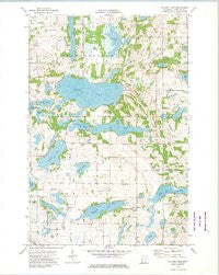
~ Stalker Lake MN topo map, 1:24000 scale, 7.5 X 7.5 Minute, Historical, 1973, updated 1975
Stalker Lake, Minnesota, USGS topographic map dated 1973.
Includes geographic coordinates (latitude and longitude). This topographic map is suitable for hiking, camping, and exploring, or framing it as a wall map.
Printed on-demand using high resolution imagery, on heavy weight and acid free paper, or alternatively on a variety of synthetic materials.
Topos available on paper, Waterproof, Poly, or Tyvek. Usually shipping rolled, unless combined with other folded maps in one order.
- Product Number: USGS-5988944
- Free digital map download (high-resolution, GeoPDF): Stalker Lake, Minnesota (file size: 9 MB)
- Map Size: please refer to the dimensions of the GeoPDF map above
- Weight (paper map): ca. 55 grams
- Map Type: POD USGS Topographic Map
- Map Series: HTMC
- Map Verison: Historical
- Cell ID: 76651
- Scan ID: 505891
- Imprint Year: 1975
- Woodland Tint: Yes
- Aerial Photo Year: 1972
- Field Check Year: 1973
- Datum: NAD27
- Map Projection: Lambert Conformal Conic
- Map published by United States Geological Survey
- Map Language: English
- Scanner Resolution: 508 dpi
- Map Cell Name: Stalker Lake
- Grid size: 7.5 X 7.5 Minute
- Date on map: 1973
- Map Scale: 1:24000
- Geographical region: Minnesota, United States
Neighboring Maps:
All neighboring USGS topo maps are available for sale online at a variety of scales.
Spatial coverage:
Topo map Stalker Lake, Minnesota, covers the geographical area associated the following places:
- Hollo Lake - Johannes Lake - Back Lake - Bethel Church - School Number 2 (historical) - School Number 9 (historical) - School Number 20 (historical) - Long Lake - Long Lake - Johnson Lake - Blacken Lake - Lakeside Cemetery - Tamarack Lake - Evangelical Lutheran Rolling Prairie Congregational Cemetery - Tordenskjold Free Mission Church Cemetery - School Number 4 (historical) - Jolly Ann Lake - Lacey Lake - School Number 71 (historical) - Lakeway Golf Course - Sewell Lake - Township of Tordenskjold - Hanson Lake - Tordenskjold Church - Kvam Cemetery - Saint Olaf Cemetery - School Number 42 (historical) - Free Lutheran Cemetery - Bethel Cemetery - Stenerson Lake - KVAM Church - Township of Saint Olaf - Saint Olaf Post Office (historical) - Stalker Lake - Whitman Lakebed
- Map Area ID: AREA46.2546.125-95.875-95.75
- Northwest corner Lat/Long code: USGSNW46.25-95.875
- Northeast corner Lat/Long code: USGSNE46.25-95.75
- Southwest corner Lat/Long code: USGSSW46.125-95.875
- Southeast corner Lat/Long code: USGSSE46.125-95.75
- Northern map edge Latitude: 46.25
- Southern map edge Latitude: 46.125
- Western map edge Longitude: -95.875
- Eastern map edge Longitude: -95.75


