
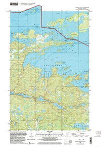
~ Soldier Point MN topo map, 1:24000 scale, 7.5 X 7.5 Minute, Historical, 1999, updated 2003
Soldier Point, Minnesota, USGS topographic map dated 1999.
Includes geographic coordinates (latitude and longitude). This topographic map is suitable for hiking, camping, and exploring, or framing it as a wall map.
Printed on-demand using high resolution imagery, on heavy weight and acid free paper, or alternatively on a variety of synthetic materials.
Topos available on paper, Waterproof, Poly, or Tyvek. Usually shipping rolled, unless combined with other folded maps in one order.
- Product Number: USGS-5988778
- Free digital map download (high-resolution, GeoPDF): Soldier Point, Minnesota (file size: 7 MB)
- Map Size: please refer to the dimensions of the GeoPDF map above
- Weight (paper map): ca. 55 grams
- Map Type: POD USGS Topographic Map
- Map Series: HTMC
- Map Verison: Historical
- Cell ID: 42016
- Scan ID: 805893
- Imprint Year: 2003
- Woodland Tint: Yes
- Aerial Photo Year: 1999
- Datum: NAD83
- Map Projection: Universal Transverse Mercator
- Map published by United States Geological Survey
- Keywords: Overedge with No Adjacent Map
- Map Language: English
- Scanner Resolution: 508 dpi
- Map Cell Name: Soldier Point
- Grid size: 7.5 X 7.5 Minute
- Date on map: 1999
- Map Scale: 1:24000
- Geographical region: Minnesota, United States
Neighboring Maps:
All neighboring USGS topo maps are available for sale online at a variety of scales.
Spatial coverage:
Topo map Soldier Point, Minnesota, covers the geographical area associated the following places:
- Loiten Lake - Gaylord Point - Hitchcock Bay - Hitchcock Island - Saginaw Bay - Nelson Island - Locator Lake - Kawawia Island - Quill Lake - Soldier Point - War Club Lake - Finlander Island - Frank Island - Lost Bay - Shoepack Lake - Brule Narrows - One Tree Island - Payson Island - Duckfoot Island - Marion Bay - Harbor Island - Finlander Bay
- Map Area ID: AREA48.62548.5-93-92.875
- Northwest corner Lat/Long code: USGSNW48.625-93
- Northeast corner Lat/Long code: USGSNE48.625-92.875
- Southwest corner Lat/Long code: USGSSW48.5-93
- Southeast corner Lat/Long code: USGSSE48.5-92.875
- Northern map edge Latitude: 48.625
- Southern map edge Latitude: 48.5
- Western map edge Longitude: -93
- Eastern map edge Longitude: -92.875


