
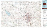
~ Wichita KS topo map, 1:100000 scale, 30 X 60 Minute, Historical, 1990, updated 1990
Wichita, Kansas, USGS topographic map dated 1990.
Includes geographic coordinates (latitude and longitude). This topographic map is suitable for hiking, camping, and exploring, or framing it as a wall map.
Printed on-demand using high resolution imagery, on heavy weight and acid free paper, or alternatively on a variety of synthetic materials.
Topos available on paper, Waterproof, Poly, or Tyvek. Usually shipping rolled, unless combined with other folded maps in one order.
- Product Number: USGS-5974378
- Free digital map download (high-resolution, GeoPDF): Wichita, Kansas (file size: 17 MB)
- Map Size: please refer to the dimensions of the GeoPDF map above
- Weight (paper map): ca. 55 grams
- Map Type: POD USGS Topographic Map
- Map Series: HTMC
- Map Verison: Historical
- Cell ID: 68586
- Scan ID: 512934
- Imprint Year: 1990
- Woodland Tint: Yes
- Aerial Photo Year: 1985
- Edit Year: 1990
- Datum: NAD27
- Map Projection: Universal Transverse Mercator
- Map published by United States Geological Survey
- Map Language: English
- Scanner Resolution: 508 dpi
- Map Cell Name: Wichita
- Grid size: 30 X 60 Minute
- Date on map: 1990
- Map Scale: 1:100000
- Geographical region: Kansas, United States
Neighboring Maps:
All neighboring USGS topo maps are available for sale online at a variety of scales.
Spatial coverage:
Topo map Wichita, Kansas, covers the geographical area associated the following places:
- K and R Mobile Home Park - Reynolds Mobile Home Park - Linnell Mobile Home Park - Mathis Mobile Home Park - Riverside - Mount Vernon - Lansdowne - Arthur Heights - Mobile Manor Estates Mobile Home Park - Connell - Waterloo - County Acres - Bayneville - Bonnie Brae - Benton - Harbor Mobile Home Park - Arkansas Mobile Home Park - Navajo Lake Estates Mobile Home Park - Cow Town - Pleasant Valley Mobile Home Park - Air Capital Mobile Home Park - Andover - Young Mobile Home Park - Darlow - Oak Court Mobile Home Court - Suburban Mobile Home Park - Goddard - Reds Mobile Home Park - Browns Mobile Home Park - Prairie Village - Forest Hills - Kechi - Country Acres Mobile Home Park - Tolerville - Westlink Village - Haven - Maple Village Mobile Home Park - Midway - Springdale - Lynwood Acres Mobile Home Park - Kamar Parkette Trailer Park - Linwood Acres - Andover Mobile Home Estates - Oaklawn - Valley Center - Midway - Conestoga Mobile Home Park - Annelly - Wego-Waco - Cambridge Mobile Home Park - Berwet - Childs Acres - Sunset Park - Oakwood Manor Mobile Home Park - Fishin Mobile Home Park - Sunview Mobile Home Park - Woodlands Mobile Home Park - Hidden Park Mobile Home Park - Rolling Meadows Mobile Home Park - Brookhaven - North Star Mobile Home Park - Sand Burr Hill - Sunnydale - Prairie Hills Mobile Home Park - Wichita Regency Mobile Home Community - Midtown Mobile Home Park - Bentley - Murdock - Oaks Mobile Home Park - Park East - McLains - Circle B Mobile Home Park - S and L Mobile Home Park - Pinaire Mobile Home Park - Yoder - Purcell - Patterson - Greenwich Heights - Castleton - Elmer - Midland - Twin Oaks Estates Mobile Home Park - Haysville - Mount Hope - Deer Lake Mobile Home Estates - South Seneca Gardens - Thompsons Mobile Home Park - Southborough Estates Mobile Home Park - Midland Park - Lamplighter Mobile Home Park - Keeler - Willowood Estates Mobile Home Park - Lakeside Manufactured Home Community - Little River Mobile Home Park - Lifestyle Mobile Home Park - Dicks Mobile Home Park - Schulte - Peachwood Manor Mobile Home Park - The Woodlands Mobile Home Park - Suppesville
- Map Area ID: AREA3837.5-98-97
- Northwest corner Lat/Long code: USGSNW38-98
- Northeast corner Lat/Long code: USGSNE38-97
- Southwest corner Lat/Long code: USGSSW37.5-98
- Southeast corner Lat/Long code: USGSSE37.5-97
- Northern map edge Latitude: 38
- Southern map edge Latitude: 37.5
- Western map edge Longitude: -98
- Eastern map edge Longitude: -97


