
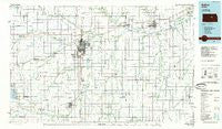
~ Salina KS topo map, 1:100000 scale, 30 X 60 Minute, Historical, 1985, updated 1985
Salina, Kansas, USGS topographic map dated 1985.
Includes geographic coordinates (latitude and longitude). This topographic map is suitable for hiking, camping, and exploring, or framing it as a wall map.
Printed on-demand using high resolution imagery, on heavy weight and acid free paper, or alternatively on a variety of synthetic materials.
Topos available on paper, Waterproof, Poly, or Tyvek. Usually shipping rolled, unless combined with other folded maps in one order.
- Product Number: USGS-5973530
- Free digital map download (high-resolution, GeoPDF): Salina, Kansas (file size: 12 MB)
- Map Size: please refer to the dimensions of the GeoPDF map above
- Weight (paper map): ca. 55 grams
- Map Type: POD USGS Topographic Map
- Map Series: HTMC
- Map Verison: Historical
- Cell ID: 72192
- Scan ID: 801638
- Imprint Year: 1985
- Woodland Tint: Yes
- Aerial Photo Year: 1981
- Edit Year: 1985
- Datum: NAD27
- Map Projection: Universal Transverse Mercator
- Planimetric: Yes
- Map published by United States Geological Survey
- Map Language: English
- Scanner Resolution: 508 dpi
- Map Cell Name: Salina
- Grid size: 30 X 60 Minute
- Date on map: 1985
- Map Scale: 1:100000
- Geographical region: Kansas, United States
Neighboring Maps:
All neighboring USGS topo maps are available for sale online at a variety of scales.
Spatial coverage:
Topo map Salina, Kansas, covers the geographical area associated the following places:
- John's Mobile Home Park - Bridgeport - M and M Mobile Home Court - Enterprise - Verdi - Roxbury - Sand Spring - Chapman - Detroit - Hedville - Gypsum - Lindsborg - Luther Ralph Mobile Home Park - Phillips Village (historical) - Trenton - Brookville - Jenkins - Abilene - Rishel - Navarre - Terra Cotta - Kipp - Salina - Falun - Salemsborg - Prairie Village Mobile Home Park - Pearl - Langley - Carlton - Golden Spur Mobile Home Park - Mackie - Patio Mobile Home Manor - Ramona - Arcola - Solomon - Assaria - New Cambria - Culver - Cedar Creek Mobile Home Park - Acme - Kanopolis Lake Park - Dillon - Red Rock Mobile Home Park - Niles - Holland - Venango - Freemount - Juniata - Cottonwood Mobile Home Park - Mentor - El Haro Mobile Home Park - Hope - Del - Ray Mobile Estates - Bavaria - Smolan - Elmo - Sundowner West Meadows Mobile Home Park - Marydel - Glendale - Marquette - Tampa - Southwestern Mobile Home Park - Hallville - Smokey Valley Mobile Home Park - Shamrock Mobile Home Estates - Jacobs - Shipton
- Map Area ID: AREA3938.5-98-97
- Northwest corner Lat/Long code: USGSNW39-98
- Northeast corner Lat/Long code: USGSNE39-97
- Southwest corner Lat/Long code: USGSSW38.5-98
- Southeast corner Lat/Long code: USGSSE38.5-97
- Northern map edge Latitude: 39
- Southern map edge Latitude: 38.5
- Western map edge Longitude: -98
- Eastern map edge Longitude: -97


