
~ Pratt KS topo map, 1:250000 scale, 1 X 2 Degree, Historical, 1955, updated 1978
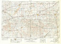
Pratt, Kansas, USGS topographic map dated 1955.
Includes geographic coordinates (latitude and longitude). This topographic map is suitable for hiking, camping, and exploring, or framing it as a wall map.
Printed on-demand using high resolution imagery, on heavy weight and acid free paper, or alternatively on a variety of synthetic materials.
Topos available on paper, Waterproof, Poly, or Tyvek. Usually shipping rolled, unless combined with other folded maps in one order.
- Product Number: USGS-5973270
- Free digital map download (high-resolution, GeoPDF): Pratt, Kansas (file size: 12 MB)
- Map Size: please refer to the dimensions of the GeoPDF map above
- Weight (paper map): ca. 55 grams
- Map Type: POD USGS Topographic Map
- Map Series: HTMC
- Map Verison: Historical
- Cell ID: 68971
- Scan ID: 801947
- Imprint Year: 1978
- Woodland Tint: Yes
- Aerial Photo Year: 1954
- Edit Year: 1969
- Field Check Year: 1955
- Datum: NAD27
- Map Projection: Transverse Mercator
- Map published by United States Geological Survey
- Map published by: Military, Other
- Map Language: English
- Scanner Resolution: 508 dpi
- Map Cell Name: Pratt
- Grid size: 1 X 2 Degree
- Date on map: 1955
- Map Scale: 1:250000
- Geographical region: Kansas, United States
Neighboring Maps:
All neighboring USGS topo maps are available for sale online at a variety of scales.
Spatial coverage:
Topo map Pratt, Kansas, covers the geographical area associated the following places:
- Protection - Kinsley - Varner - Crystal Springs - Trousdale - Forest City - Wilroads Gardens - Wellsford - Zenda - Pixley - Preston - Offerle - Country Mobile Home Estates Community - Fort Dodge - Zenith - Alameda - Belvidere - Williams (historical) - Eldred - Harper - Deerhead - Green Acres Trailer Park - Abbyville - Hodges - Spearville - Hazelton - Kiowa - Mullinville - Macksville - Cunningham - Haviland - Hardtner - Plevna - Dillwyn - Wilroads - Sylvia - Windhorst - Kingman - Mingona - Greensburg - Bellefont - Ranchwood Mobile Estates - Turon - Happy Homes Park - Arlington - Penalosa - Ardell - Pratt - Las Brisas Mobile Home Park - Englewood - Lake City - Saint Leo - Corwin - Pretty Prairie - Georgia - D and D Mobile Home Park - Belpre - Centerview - Nettleton - Fellsburg - Coats - Natrona - Kingsdown - Basil - Duquoin - Ashland - Bucklin - Bloom - Wilmore - Waldron - Lexington - Elm Mills - Stubbs - Willowdale - Midway - Sharon - Byers - Springvale - Gerlane - Waldeck - Medicine Lodge - Lerado - Partridge - Neola - Anthony - Ruella - Crisfield - Stafford - Attica - Langdon - Iuka - Cullison - Calista - Mound Street Mobile Home Park - Skellyville - Nashville - Coldwater - Joy - Brenham - Croft
- Map Area ID: AREA3837-100-98
- Northwest corner Lat/Long code: USGSNW38-100
- Northeast corner Lat/Long code: USGSNE38-98
- Southwest corner Lat/Long code: USGSSW37-100
- Southeast corner Lat/Long code: USGSSE37-98
- Northern map edge Latitude: 38
- Southern map edge Latitude: 37
- Western map edge Longitude: -100
- Eastern map edge Longitude: -98


