
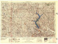
~ Manhattan KS topo map, 1:250000 scale, 1 X 2 Degree, Historical, 1957, updated 1957
Manhattan, Kansas, USGS topographic map dated 1957.
Includes geographic coordinates (latitude and longitude). This topographic map is suitable for hiking, camping, and exploring, or framing it as a wall map.
Printed on-demand using high resolution imagery, on heavy weight and acid free paper, or alternatively on a variety of synthetic materials.
Topos available on paper, Waterproof, Poly, or Tyvek. Usually shipping rolled, unless combined with other folded maps in one order.
- Product Number: USGS-5972336
- Free digital map download (high-resolution, GeoPDF): Manhattan, Kansas (file size: 13 MB)
- Map Size: please refer to the dimensions of the GeoPDF map above
- Weight (paper map): ca. 55 grams
- Map Type: POD USGS Topographic Map
- Map Series: HTMC
- Map Verison: Historical
- Cell ID: 72237
- Scan ID: 801881
- Imprint Year: 1957
- Woodland Tint: Yes
- Aerial Photo Year: 1954
- Field Check Year: 1955
- Datum: NAD27
- Map Projection: Transverse Mercator
- Map published by United States Army Corps of Engineers
- Map published by United States Army
- Map Language: English
- Scanner Resolution: 508 dpi
- Map Cell Name: Manhattan
- Grid size: 1 X 2 Degree
- Date on map: 1957
- Map Scale: 1:250000
- Geographical region: Kansas, United States
Neighboring Maps:
All neighboring USGS topo maps are available for sale online at a variety of scales.
Spatial coverage:
Topo map Manhattan, Kansas, covers the geographical area associated the following places:
- Tescott - Palmer - Milford - Belleville - Country Acres Trailer Court - Westmoreland - Marysville - Vera - Summerfield - Scandia - Laclede - Coursens Grove (historical) - Warwick - Home - Lovewell - Ada - Double J Mobile Home Park - Zeandale - Bluemont Hill - Green - Huscher - Clifton - Emmett - Riverside Mobile Home Park - Blue Valley Mobile Home Park - Oscar (historical) - Upland - Upland - Alida - Kackley - Nolan - Cook - Brantford - Axtell - Beattie - Harbine - Spence - Calderhead - Havensville - Olsburg - Mahaska - Swamp Angel - Asherville - Tabor - Onaga - Saint Bridget - Black Squirrel Mobile Home Park - Duluth - Wakefield - Clyde - Belvue - Scottsville - Lasita - Kimeo - Bennington - Redbud Estates Manufactured Home Community - Lakeside Mobile Home Court - Barret - Junction City - Lindsey - Munden - Bremen - Oneonta (historical) - McFarland - Ashwood Mobile Home Park - Vine Creek - Wayne - Rosaco - Lamar - Maple Hill - Bestwall - Jamestown - Barnes - Lillis - Centralia - Corning - J and L Mobile Home Park - Ames - Oak Hill - Oketo - Haworth - Eureka Lake - Neuchatel - Scottish Square Mobile Home Park - White Rock - Garfield Center - Randolph - Beckerville - Courtland - America City - Keats - Alcove Spring - Fairmont - Simpson - Frankfort - Four Seasons Mobile Home Estates - Vermillion - Manchester - Miltonvale - Newbury
- Map Area ID: AREA4039-98-96
- Northwest corner Lat/Long code: USGSNW40-98
- Northeast corner Lat/Long code: USGSNE40-96
- Southwest corner Lat/Long code: USGSSW39-98
- Southeast corner Lat/Long code: USGSSE39-96
- Northern map edge Latitude: 40
- Southern map edge Latitude: 39
- Western map edge Longitude: -98
- Eastern map edge Longitude: -96


