
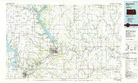
~ Manhattan KS topo map, 1:100000 scale, 30 X 60 Minute, Historical, 1985, updated 1986
Manhattan, Kansas, USGS topographic map dated 1985.
Includes geographic coordinates (latitude and longitude). This topographic map is suitable for hiking, camping, and exploring, or framing it as a wall map.
Printed on-demand using high resolution imagery, on heavy weight and acid free paper, or alternatively on a variety of synthetic materials.
Topos available on paper, Waterproof, Poly, or Tyvek. Usually shipping rolled, unless combined with other folded maps in one order.
- Product Number: USGS-5972330
- Free digital map download (high-resolution, GeoPDF): Manhattan, Kansas (file size: 14 MB)
- Map Size: please refer to the dimensions of the GeoPDF map above
- Weight (paper map): ca. 55 grams
- Map Type: POD USGS Topographic Map
- Map Series: HTMC
- Map Verison: Historical
- Cell ID: 67898
- Scan ID: 801614
- Imprint Year: 1986
- Woodland Tint: Yes
- Aerial Photo Year: 1981
- Edit Year: 1985
- Datum: NAD27
- Map Projection: Universal Transverse Mercator
- Planimetric: Yes
- Map published by United States Geological Survey
- Map Language: English
- Scanner Resolution: 508 dpi
- Map Cell Name: Manhattan
- Grid size: 30 X 60 Minute
- Date on map: 1985
- Map Scale: 1:100000
- Geographical region: Kansas, United States
Neighboring Maps:
All neighboring USGS topo maps are available for sale online at a variety of scales.
Spatial coverage:
Topo map Manhattan, Kansas, covers the geographical area associated the following places:
- Aikins - Rocky Ford Mobile Home Park - Pillsbury Crossing - Riverside Mobile Home Park - Fairmont - Mobile Villa Trailer Court - In the Field Mobile Home Park - Midway Mobile Home Park - Saint Marys - Riverchase Mobile Home Park - Manhattan - Leonardville - Fostoria - Ashwood Mobile Home Park - Emmett - Milford - Ogden - Walsburg - Saint George - Lakeside Mobile Home Court - Colonial Gardens Mobile Homes - Maple Hill - Humdinger Trailer Park - Sunset Park - Zeandale - Grandview Plaza - Lasita - Bretz's Mobile Home Park - Bala - Northwind Mobile Home Park - Junction City Regency Mobile Home Park - Scottish Square Mobile Home Park - Olsburg - Newbury - Vera - Walnut Grove Mobile Home Park - Junction City - Keating Mobile Home Park - Cottonwood Mobile Home Estates - Blaine - J and L Mobile Home Park - Four Seasons Mobile Home Estates - Blue Valley Mobile Home Park - Louisville - Riley - Westmoreland - Belvue - Onaga - McFarland - Miller Mobile Home Court - Paxico - Wabaunsee - Bluemont Hill - Keats - Laclede - Randolph - Saint Clere - Alida - Elm Hollow Corner - Eureka Lake - Redbud Estates Manufactured Home Community - Winkler - Saint George Mobile Home Park - Alma - Rocky Ford - Swamp Angel - Flush - Wamego
- Map Area ID: AREA39.539-97-96
- Northwest corner Lat/Long code: USGSNW39.5-97
- Northeast corner Lat/Long code: USGSNE39.5-96
- Southwest corner Lat/Long code: USGSSW39-97
- Southeast corner Lat/Long code: USGSSE39-96
- Northern map edge Latitude: 39.5
- Southern map edge Latitude: 39
- Western map edge Longitude: -97
- Eastern map edge Longitude: -96


