
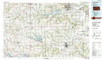
~ Lawrence KS topo map, 1:100000 scale, 30 X 60 Minute, Historical, 1983, updated 1984
Lawrence, Kansas, USGS topographic map dated 1983.
Includes geographic coordinates (latitude and longitude). This topographic map is suitable for hiking, camping, and exploring, or framing it as a wall map.
Printed on-demand using high resolution imagery, on heavy weight and acid free paper, or alternatively on a variety of synthetic materials.
Topos available on paper, Waterproof, Poly, or Tyvek. Usually shipping rolled, unless combined with other folded maps in one order.
- Product Number: USGS-5972062
- Free digital map download (high-resolution, GeoPDF): Lawrence, Kansas (file size: 18 MB)
- Map Size: please refer to the dimensions of the GeoPDF map above
- Weight (paper map): ca. 55 grams
- Map Type: POD USGS Topographic Map
- Map Series: HTMC
- Map Verison: Historical
- Cell ID: 67829
- Scan ID: 801846
- Imprint Year: 1984
- Woodland Tint: Yes
- Aerial Photo Year: 1981
- Edit Year: 1983
- Datum: NAD27
- Map Projection: Universal Transverse Mercator
- Map published by United States Geological Survey
- Map Language: English
- Scanner Resolution: 508 dpi
- Map Cell Name: Lawrence
- Grid size: 30 X 60 Minute
- Date on map: 1983
- Map Scale: 1:100000
- Geographical region: Kansas, United States
Neighboring Maps:
All neighboring USGS topo maps are available for sale online at a variety of scales.
Spatial coverage:
Topo map Lawrence, Kansas, covers the geographical area associated the following places:
- Mobile Village II Mobile Home Park - South Village Mobile Home Park - Ransomville - Mineral Springs - Globe - Four Corners - Green Acres Park Mobile Home Park - Shady Acres Mobile Home Park - Reading - Michigan Valley - Noria - Bismark Grove - Stull - Eudora - Homewood - Barclay - Sibleyville - Vinland - Harper Woods Mobile Home Park - Richter - Cherrywoods Mobile Home Park - Richland - O'Brien - Lawrence - Worden - Swissvale - Weaver - Brookwood Mobile Home Park - Watson - Gaslight Village Mobile Home Park - Baldwin City - Melvern - Miller - Clearfield - Dover - Harveyville - Hesper - Hillside Mobile Home Park - Rantoul - Lindbloom Park (historical) - Prairie Center (historical) - Peoria - Lyndon - Black Jack - Easy Living Mobile Home Park - Berryton - Stanton - Scranton - Lone Star - Kanwaka - Imes - Pauline - Osage City - Mathews Park - Grandview Mobile Home Park - Sunflower Mobile Home Park - Clinton - Maple Leaf Mobile Home Park - Fall Leaf - Wellsville - Coachlight Village Mobile Home Courts South - Clearview City - Paradise Mobile Home Park - Cullen Village - Centropolis - Shawnee Hills Mobile Home Park - Pine Hills Mobile Home Park - Blue Oaks and Live Oaks Mobile Home Park - Norwood - Auburn - Peterton - Ridgewood Estates Mobile Home Park - Acres Mobile Home Estate Park - Riverside Mobile Home Park - Lyndon Station - Overbrook - Edgerton - Burlingame - Ottawa Junction - Pleasant Grove - Green Acres Mobile Home Park - Terra Heights - Wilmington - Le Loup - Wakarusa - Quenemo - Broken Arrow Park - Edgerton Mobile Home Park - Vassar - B N Junction - Ottawa - Pomona - Carbondale
- Map Area ID: AREA3938.5-96-95
- Northwest corner Lat/Long code: USGSNW39-96
- Northeast corner Lat/Long code: USGSNE39-95
- Southwest corner Lat/Long code: USGSSW38.5-96
- Southeast corner Lat/Long code: USGSSE38.5-95
- Northern map edge Latitude: 39
- Southern map edge Latitude: 38.5
- Western map edge Longitude: -96
- Eastern map edge Longitude: -95


