
~ Lawrence KS topo map, 1:250000 scale, 1 X 2 Degree, Historical, 1956, updated 1967
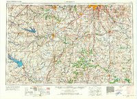
Lawrence, Kansas, USGS topographic map dated 1956.
Includes geographic coordinates (latitude and longitude). This topographic map is suitable for hiking, camping, and exploring, or framing it as a wall map.
Printed on-demand using high resolution imagery, on heavy weight and acid free paper, or alternatively on a variety of synthetic materials.
Topos available on paper, Waterproof, Poly, or Tyvek. Usually shipping rolled, unless combined with other folded maps in one order.
- Product Number: USGS-5972054
- Free digital map download (high-resolution, GeoPDF): Lawrence, Kansas (file size: 12 MB)
- Map Size: please refer to the dimensions of the GeoPDF map above
- Weight (paper map): ca. 55 grams
- Map Type: POD USGS Topographic Map
- Map Series: HTMC
- Map Verison: Historical
- Cell ID: 68869
- Scan ID: 801842
- Imprint Year: 1967
- Woodland Tint: Yes
- Aerial Photo Year: 1950
- Edit Year: 1967
- Field Check Year: 1956
- Datum: NAD27
- Map Projection: Transverse Mercator
- Map published by United States Geological Survey
- Map published by United States Army Corps of Engineers
- Map published by United States Army
- Map Language: English
- Scanner Resolution: 508 dpi
- Map Cell Name: Lawrence
- Grid size: 1 X 2 Degree
- Date on map: 1956
- Map Scale: 1:250000
- Geographical region: Kansas, United States
Neighboring Maps:
All neighboring USGS topo maps are available for sale online at a variety of scales.
Spatial coverage:
Topo map Lawrence, Kansas, covers the geographical area associated the following places:
- Edgerton Mobile Home Park - Cherrywoods Mobile Home Park - South Drexel - East Lynne - Ransomville - Oviet (historical) - Louisburg Manufactured Home Estates - Harris - Lindale - Drexel Corner - Melvern - Johnstown - Dover - Grandview - Medford - Waverly - Overland Park - Barnesville - Morse - Kingsville - Centerville - Broken Arrow Park - Vassar - Cadmus - Lone Tree - Fontana - Wyoming (historical) - Olathe - Shawnee Hills Mobile Home Park - Lawrence - Kenneth - Virginia - Coleman - Harper Woods Mobile Home Park - Jacobs Creek Landing - Dallas - Mulberry - Nyhart - Pleasant Grove - Watson - Amos - Osawatomie - Ocheltree - Mobile Village II Mobile Home Park - Merwin - Geneva - Monteith Junction - Scipio - Gowdy - Pomona - Lyndon Station - Pleasant Gap - Blue Oaks and Live Oaks Mobile Home Park - Redel - Vale - Botham Mobile Home Park - B N Junction - Strasburg - Huber - Lyndon - Holmes Park - Arvonia - Hillsdale - Worden - Ridgewood Estates Mobile Home Park - Clare - Princeton Mobile Home Park - Black Jack - Toy Mobile Home Park - Garden City - Gaslight Village Mobile Home Park - Gunn City - Colony - Hesper - New Santa Fe - Stilwell - Martin City - Cornland - Farlinville - Little Blue - Clinton - B And L Mobile Home Park - Lackmans - Loch Lloyd - Lake Winnebago - Athol - Stanton - Fall Leaf - Beagle - Welda - Beto Junction - Jeffreys - Westphalia - Richland - Urich - Union Point - Garnett - Chiles - Truman Corners - Prairie Village
- Map Area ID: AREA3938-96-94
- Northwest corner Lat/Long code: USGSNW39-96
- Northeast corner Lat/Long code: USGSNE39-94
- Southwest corner Lat/Long code: USGSSW38-96
- Southeast corner Lat/Long code: USGSSE38-94
- Northern map edge Latitude: 39
- Southern map edge Latitude: 38
- Western map edge Longitude: -96
- Eastern map edge Longitude: -94


