
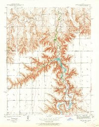
~ Lake Mc Bride KS topo map, 1:24000 scale, 7.5 X 7.5 Minute, Historical, 1939, updated 1962
Lake Mc Bride, Kansas, USGS topographic map dated 1939.
Includes geographic coordinates (latitude and longitude). This topographic map is suitable for hiking, camping, and exploring, or framing it as a wall map.
Printed on-demand using high resolution imagery, on heavy weight and acid free paper, or alternatively on a variety of synthetic materials.
Topos available on paper, Waterproof, Poly, or Tyvek. Usually shipping rolled, unless combined with other folded maps in one order.
- Product Number: USGS-5971940
- Free digital map download (high-resolution, GeoPDF): Lake Mc Bride, Kansas (file size: 8 MB)
- Map Size: please refer to the dimensions of the GeoPDF map above
- Weight (paper map): ca. 55 grams
- Map Type: POD USGS Topographic Map
- Map Series: HTMC
- Map Verison: Historical
- Cell ID: 24642
- Scan ID: 801835
- Imprint Year: 1962
- Woodland Tint: Yes
- Survey Year: 1939
- Datum: NAD27
- Map Projection: Polyconic
- Map published by United States Geological Survey
- Map Language: English
- Scanner Resolution: 508 dpi
- Map Cell Name: Lake Scott
- Grid size: 7.5 X 7.5 Minute
- Date on map: 1939
- Map Scale: 1:24000
- Geographical region: Kansas, United States
Neighboring Maps:
All neighboring USGS topo maps are available for sale online at a variety of scales.
Spatial coverage:
Topo map Lake Mc Bride, Kansas, covers the geographical area associated the following places:
- Battendorf Canyon - Township of Lees - Lake Scott - Lakeside Campground - Camp Christy - Carpenter Chapel - Landon Draw - Scott State Park Lakebank Drive Campground - Devils Backbone - Camp Lakeside - Squaws Den Monument - Scott State Park Bull Canyon South Campground - Barrel Springs Trout Pond - Suicide Bluffs - Squaws Den Battleground - Scott County State Park Dam - Elm Camping Area - Prairie View School (historical) - Scott State Game Management Area - Christy Canyon - Horsethief Canyon - Lake View Campground - Lake Scott State Park - McBride Monument - State Park School (historical) - Epler Canyon - Upper Christy Lake (historical) - Barrel Springs - Morgan Draw - White Womans Grave - Timber Canyon - Christy Lake (historical) - Christy Dam (historical) - Steele Monument - Garvin Canyon - El Cuartelejo Ruins - Shafer Canyon - Sand Draw - Battle Canyon - Glendale School (historical) - Scott State Park Timber Canyon Campground - Scott County State Lake - Circle Drive Campground - Steele Homestead Museum
- Map Area ID: AREA38.7538.625-101-100.875
- Northwest corner Lat/Long code: USGSNW38.75-101
- Northeast corner Lat/Long code: USGSNE38.75-100.875
- Southwest corner Lat/Long code: USGSSW38.625-101
- Southeast corner Lat/Long code: USGSSE38.625-100.875
- Northern map edge Latitude: 38.75
- Southern map edge Latitude: 38.625
- Western map edge Longitude: -101
- Eastern map edge Longitude: -100.875


