
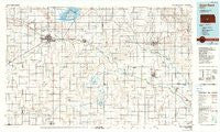
~ Great Bend KS topo map, 1:100000 scale, 30 X 60 Minute, Historical, 1985, updated 1990
Great Bend, Kansas, USGS topographic map dated 1985.
Includes geographic coordinates (latitude and longitude). This topographic map is suitable for hiking, camping, and exploring, or framing it as a wall map.
Printed on-demand using high resolution imagery, on heavy weight and acid free paper, or alternatively on a variety of synthetic materials.
Topos available on paper, Waterproof, Poly, or Tyvek. Usually shipping rolled, unless combined with other folded maps in one order.
- Product Number: USGS-5971242
- Free digital map download (high-resolution, GeoPDF): Great Bend, Kansas (file size: 14 MB)
- Map Size: please refer to the dimensions of the GeoPDF map above
- Weight (paper map): ca. 55 grams
- Map Type: POD USGS Topographic Map
- Map Series: HTMC
- Map Verison: Historical
- Cell ID: 67604
- Scan ID: 801596
- Imprint Year: 1990
- Woodland Tint: Yes
- Photo Inspection Year: 1985
- Aerial Photo Year: 1981
- Edit Year: 1985
- Datum: NAD27
- Map Projection: Universal Transverse Mercator
- Map published by United States Geological Survey
- Map Language: English
- Scanner Resolution: 508 dpi
- Map Cell Name: Great Bend
- Grid size: 30 X 60 Minute
- Date on map: 1985
- Map Scale: 1:100000
- Geographical region: Kansas, United States
Neighboring Maps:
All neighboring USGS topo maps are available for sale online at a variety of scales.
Spatial coverage:
Topo map Great Bend, Kansas, covers the geographical area associated the following places:
- Huntsville - Mitchell - Dartmouth - Kilbourns Corner - Whiteside - Kanbrick - Sunview Mobile Home Park - Anchorway - Ray - Ellinwood - Dundee - Pawnee Rock - Little River - Charters Corner - Adams Corner - Silica - Great Bend - McVays Corner - Chase - Heizer - Sterling - Seward - Village Mobile Home Park - Western Acres Mobile Home Park - Alden - Lyons - Raymond - South Side Mobile Court - Saxman - Radium - Yaggy - St. John - All Seasons Mobile Home Community - Finer Mobile Home Park - Pollard - Nickerson - Galt - Hudson
- Map Area ID: AREA38.538-99-98
- Northwest corner Lat/Long code: USGSNW38.5-99
- Northeast corner Lat/Long code: USGSNE38.5-98
- Southwest corner Lat/Long code: USGSSW38-99
- Southeast corner Lat/Long code: USGSSE38-98
- Northern map edge Latitude: 38.5
- Southern map edge Latitude: 38
- Western map edge Longitude: -99
- Eastern map edge Longitude: -98


