
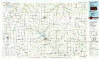
~ Council Grove KS topo map, 1:100000 scale, 30 X 60 Minute, Historical, 1985, updated 1985
Council Grove, Kansas, USGS topographic map dated 1985.
Includes geographic coordinates (latitude and longitude). This topographic map is suitable for hiking, camping, and exploring, or framing it as a wall map.
Printed on-demand using high resolution imagery, on heavy weight and acid free paper, or alternatively on a variety of synthetic materials.
Topos available on paper, Waterproof, Poly, or Tyvek. Usually shipping rolled, unless combined with other folded maps in one order.
- Product Number: USGS-5970476
- Free digital map download (high-resolution, GeoPDF): Council Grove, Kansas (file size: 12 MB)
- Map Size: please refer to the dimensions of the GeoPDF map above
- Weight (paper map): ca. 55 grams
- Map Type: POD USGS Topographic Map
- Map Series: HTMC
- Map Verison: Historical
- Cell ID: 72149
- Scan ID: 801581
- Imprint Year: 1985
- Woodland Tint: Yes
- Aerial Photo Year: 1981
- Edit Year: 1985
- Datum: NAD27
- Map Projection: Universal Transverse Mercator
- Planimetric: Yes
- Map published by United States Geological Survey
- Map Language: English
- Scanner Resolution: 508 dpi
- Map Cell Name: Council Grove
- Grid size: 30 X 60 Minute
- Date on map: 1985
- Map Scale: 1:100000
- Geographical region: Kansas, United States
Neighboring Maps:
All neighboring USGS topo maps are available for sale online at a variety of scales.
Spatial coverage:
Topo map Council Grove, Kansas, covers the geographical area associated the following places:
- Wreford - Dwight - Volland - Dunlap - Downing (historical) - Wilsey - Helmick - Lost Springs - Pioneer Mobile Home Village - Woodbine - White City - Eskridge - Herington - Diamond Springs - Shady Brook - Alta Vista - Burdick - Koepke Mobile Manor - Americus - Kansas Falls - Keene - Allendorph - Hessdale - Allen - Admire - Latimer - Parkerville - Bushong - Lyona - Skiddy - Delavan - Council Grove - Kelso - Bradford
- Map Area ID: AREA3938.5-97-96
- Northwest corner Lat/Long code: USGSNW39-97
- Northeast corner Lat/Long code: USGSNE39-96
- Southwest corner Lat/Long code: USGSSW38.5-97
- Southeast corner Lat/Long code: USGSSE38.5-96
- Northern map edge Latitude: 39
- Southern map edge Latitude: 38.5
- Western map edge Longitude: -97
- Eastern map edge Longitude: -96


