
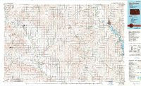
~ Clay Center KS topo map, 1:100000 scale, 30 X 60 Minute, Historical, 1985, updated 1990
Clay Center, Kansas, USGS topographic map dated 1985.
Includes geographic coordinates (latitude and longitude). This topographic map is suitable for hiking, camping, and exploring, or framing it as a wall map.
Printed on-demand using high resolution imagery, on heavy weight and acid free paper, or alternatively on a variety of synthetic materials.
Topos available on paper, Waterproof, Poly, or Tyvek. Usually shipping rolled, unless combined with other folded maps in one order.
- Product Number: USGS-5970338
- Free digital map download (high-resolution, GeoPDF): Clay Center, Kansas (file size: 17 MB)
- Map Size: please refer to the dimensions of the GeoPDF map above
- Weight (paper map): ca. 55 grams
- Map Type: POD USGS Topographic Map
- Map Series: HTMC
- Map Verison: Historical
- Cell ID: 67304
- Scan ID: 512896
- Imprint Year: 1990
- Woodland Tint: Yes
- Photo Inspection Year: 1985
- Aerial Photo Year: 1981
- Edit Year: 1985
- Datum: NAD27
- Map Projection: Universal Transverse Mercator
- Map published by United States Geological Survey
- Map Language: English
- Scanner Resolution: 508 dpi
- Map Cell Name: Clay Center
- Grid size: 30 X 60 Minute
- Date on map: 1985
- Map Scale: 1:100000
- Geographical region: Kansas, United States
Neighboring Maps:
All neighboring USGS topo maps are available for sale online at a variety of scales.
Spatial coverage:
Topo map Clay Center, Kansas, covers the geographical area associated the following places:
- Wells - Aurora - Ladysmith - Sumnerville - Delphos - Oak Hill - Glasco - Brewer - Sutphen - Idana - Beverly - Macyville - Asherville - Lamar - Hawks Landing Mobile Home Park - Simpson - Vine Creek - Upland - Bennington - Manchester - Buckeye - Broughton (historical) - Clay Center - Industry - Moonlight - Country Gardens Mobile Home Park - Tescott - Coursens Grove (historical) - Longford - Browndale - Wakefield - Milo - Alfmil - Ada - Miltonvale - Morganville - Lindsey - Minneapolis - Talmage - Green
- Map Area ID: AREA39.539-98-97
- Northwest corner Lat/Long code: USGSNW39.5-98
- Northeast corner Lat/Long code: USGSNE39.5-97
- Southwest corner Lat/Long code: USGSSW39-98
- Southeast corner Lat/Long code: USGSSE39-97
- Northern map edge Latitude: 39.5
- Southern map edge Latitude: 39
- Western map edge Longitude: -98
- Eastern map edge Longitude: -97


