
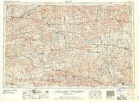
~ Beloit KS topo map, 1:250000 scale, 1 X 2 Degree, Historical, 1959, updated 1959
Beloit, Kansas, USGS topographic map dated 1959.
Includes geographic coordinates (latitude and longitude). This topographic map is suitable for hiking, camping, and exploring, or framing it as a wall map.
Printed on-demand using high resolution imagery, on heavy weight and acid free paper, or alternatively on a variety of synthetic materials.
Topos available on paper, Waterproof, Poly, or Tyvek. Usually shipping rolled, unless combined with other folded maps in one order.
- Product Number: USGS-5969890
- Free digital map download (high-resolution, GeoPDF): Beloit, Kansas (file size: 13 MB)
- Map Size: please refer to the dimensions of the GeoPDF map above
- Weight (paper map): ca. 55 grams
- Map Type: POD USGS Topographic Map
- Map Series: HTMC
- Map Verison: Historical
- Cell ID: 68669
- Scan ID: 801680
- Imprint Year: 1959
- Woodland Tint: Yes
- Aerial Photo Year: 1954
- Field Check Year: 1955
- Datum: NAD27
- Map Projection: Transverse Mercator
- Map published by United States Army Corps of Engineers
- Map published by United States Army
- Map Language: English
- Scanner Resolution: 508 dpi
- Map Cell Name: Beloit
- Grid size: 1 X 2 Degree
- Date on map: 1959
- Map Scale: 1:250000
- Geographical region: Kansas, United States
Neighboring Maps:
All neighboring USGS topo maps are available for sale online at a variety of scales.
Spatial coverage:
Topo map Beloit, Kansas, covers the geographical area associated the following places:
- Bogue - Luray - Gaylord - Ionia - Cottonwood Trailer Court - Wolf Creek - Blue Hill - Reamsville - Almena - Dentonia - Hunter - Smith Center - Solomon Rapids - Webber - Jewell - Speed - Shady Bend - Burr Oak - Dispatch - Wesley Center - Mankato - Harlan - Turkville - Woodruff - Claudell - Norton - Womer - Glade - Beloit - Stuttgart - Northbranch - Long Island - Bloomington - Codell - Salem - Fairport - Portis - Damar - Covert - Densmore - Plainville - Togo - Quartzite - Stockton - Vesper - Thornburg - Barnard - Lucas - Bellaire - Woodston - Goldenrod - Nicodemus - Corinth - Montrose - Randall - Vincent - Laton - Agra - Tipton - Cheyenne - Lebanon - Paradise - Palco - Natoma - Glen Elder - Cheyenne Gap (historical) - Hill City - Roscoe - Lincoln - WaKeeney - Calvert - Grant - Cedar - Denmark - Ash Grove - Athol - Phillipsburg - Sylvan Grove - Esbon - Kirwin - Downs - Smithfield - Gilbert - Zurich - Cawker City - Logan - Prairie View - Kensington - Forney - Alton - Otego - Osborne - Edmond - Gretna - Waldo - Penokee - Cora - Webster (historical) - Victor
- Map Area ID: AREA4039-100-98
- Northwest corner Lat/Long code: USGSNW40-100
- Northeast corner Lat/Long code: USGSNE40-98
- Southwest corner Lat/Long code: USGSSW39-100
- Southeast corner Lat/Long code: USGSSE39-98
- Northern map edge Latitude: 40
- Southern map edge Latitude: 39
- Western map edge Longitude: -100
- Eastern map edge Longitude: -98


