
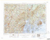
~ Bangor ME topo map, 1:250000 scale, 1 X 2 Degree, Historical, 1960, updated 1960
Bangor, Maine, USGS topographic map dated 1960.
Includes geographic coordinates (latitude and longitude). This topographic map is suitable for hiking, camping, and exploring, or framing it as a wall map.
Printed on-demand using high resolution imagery, on heavy weight and acid free paper, or alternatively on a variety of synthetic materials.
Topos available on paper, Waterproof, Poly, or Tyvek. Usually shipping rolled, unless combined with other folded maps in one order.
- Product Number: USGS-5958073
- Free digital map download (high-resolution, GeoPDF): Bangor, Maine (file size: 27 MB)
- Map Size: please refer to the dimensions of the GeoPDF map above
- Weight (paper map): ca. 55 grams
- Map Type: POD USGS Topographic Map
- Map Series: HTMC
- Map Verison: Historical
- Cell ID: 68662
- Scan ID: 460144
- Imprint Year: 1960
- Woodland Tint: Yes
- Field Check Year: 1956
- Datum: Unstated
- Map Projection: Transverse Mercator
- Map published by United States Army Corps of Engineers
- Map published by United States Army
- Map Language: English
- Scanner Resolution: 600 dpi
- Map Cell Name: Bangor
- Grid size: 1 X 2 Degree
- Date on map: 1960
- Map Scale: 1:250000
- Geographical region: Maine, United States
Neighboring Maps:
All neighboring USGS topo maps are available for sale online at a variety of scales.
Spatial coverage:
Topo map Bangor, Maine, covers the geographical area associated the following places:
- Tyler Corner - Martin Corner - Stickney Corner - West Surry - Frenchboro - Birch Harbor - Crescent Beach - South Jefferson - North Newport - Deblois - Embden - Blackinton Corners - Winnecook - Stonington - Clifton - Jones Corner - Evans Corner - Frenchs Corner - East Orrington - Newburgh Village - Harborside - Sullivan - Nickerson Mills - Wings Mills - Lower Beddington - Stetson - Clinton - East Northport - Waldo - Winthrop - Dog Corners - Pease Corner - Red Rock Corner - North Searsmont - South Thomaston - Oceanville - West Tremont - Sidney - Sprague Corner - Rainbow Home Court Mobile Home Park - South Newburgh - Trenton - Pretty Marsh - Waltham - Bangs Beach - North Penobscot - Blue Hill - Moody - Baldwin Corners - North Whitefield - Etna Center - Dane Corner - Dixon Corner - East Surry - West Brooksville - Green Lake - Nicolin (historical) - Hurds Corner - North Searsport - Morrill - Morrison Corner - Fairfield - Southwest Harbor - East Madison - North Orrington - Reynolds Corner - Townhouse Corner - West Bangor - Knox Corner - Sandy River - West Castine - Sunset - Etna - North Vassalboro - Hartland - Farmingdale - Northport - Holmes Mill - Tilton Corner - Kennedy Corner - Gregorys Corner - Flanders Corner - Owls Head - Rome Corner - North Brewer - Whites Corner - Lake City - Glendon - Leathers Corner - Orrington - Little Deer Isle - Connors Corner - South Vassalboro - North Orland - Halldale - Elliot Landing - South Waldoboro - Seal Harbor - Searsmont - West Sullivan
- Map Area ID: AREA4544-70-68
- Northwest corner Lat/Long code: USGSNW45-70
- Northeast corner Lat/Long code: USGSNE45-68
- Southwest corner Lat/Long code: USGSSW44-70
- Southeast corner Lat/Long code: USGSSE44-68
- Northern map edge Latitude: 45
- Southern map edge Latitude: 44
- Western map edge Longitude: -70
- Eastern map edge Longitude: -68


