
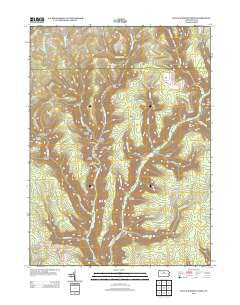
~ Young Womans Creek PA topo map, 1:24000 scale, 7.5 X 7.5 Minute, Historical, 2013
Young Womans Creek, Pennsylvania, USGS topographic map dated 2013.
Includes geographic coordinates (latitude and longitude). This topographic map is suitable for hiking, camping, and exploring, or framing it as a wall map.
Printed on-demand using high resolution imagery, on heavy weight and acid free paper, or alternatively on a variety of synthetic materials.
Topos available on paper, Waterproof, Poly, or Tyvek. Usually shipping rolled, unless combined with other folded maps in one order.
- Product Number: USGS-5948962
- Free digital map download (high-resolution, GeoPDF): Young Womans Creek, Pennsylvania (file size: 29 MB)
- Map Size: please refer to the dimensions of the GeoPDF map above
- Weight (paper map): ca. 55 grams
- Map Type: POD USGS Topographic Map
- Map Series: US Topo
- Map Verison: Historical
- Cell ID: 50155
- Datum: North American Datum of 1983
- Map Projection: Transverse Mercator
- Map Cell Name: Young Womans Creek
- Grid size: 7.5 X 7.5 Minute
- Date on map: 2013
- Map Scale: 1:24000
- Geographical region: Pennsylvania, United States
Neighboring Maps:
All neighboring USGS topo maps are available for sale online at a variety of scales.
Spatial coverage:
Topo map Young Womans Creek, Pennsylvania, covers the geographical area associated the following places:
- Lee Hollow Trail - Butler Hollow - Birch Hollow - Laurelly Fork - Post Hollow - Cannon Hole Trail - Summerson Run - Rattlesnake Trail - McCraney Run - Wildcat Trail - Mudlick Run - Calamity Hollow - Spring Brook - Dug Road Trail - Big Spring Branch - Ash Hollow Trail - Lecox Ridge - Tegerman Hollow - French Trail - Shingle Branch - Township of Chapman - Beechwood Trail - Mix Hollow Trail - Laurelly Hill Trail - Patchell Trail - Summerson Mountain - Quiggle Hollow - Daugherty Hollow Trail - Stout Hollow Trail - Mudlick Trail - Fye Camp Trail - Italian Hollow Trail - Stible Hole Trail - Morgan Hollow Trail - Greenlick Run - Merriman Hollow - Lecox Ridge Trail - Ingram Hollow - Geyser Hollow - Bull Run - Poplar Hollow - Oxbow Hollow Trail - Laurel Fork - Long Hollow - Ginseng Hollow - Daugherty Hollow - Little Greenlick Run - Shaney Brook Trail - Long Fork Trail - Oxbow Hollow - Laurel Ridge - Shingle Mill Hollow Trail - Bee Tree Hollow - Little Boyer Mill Trail - Rands Hole Trail - Lebo Run - Shaney Brook - Camp Trail - Ash Hollow - Fork Hill Trail - Stout Hollow
- Map Area ID: AREA41.541.375-77.75-77.625
- Northwest corner Lat/Long code: USGSNW41.5-77.75
- Northeast corner Lat/Long code: USGSNE41.5-77.625
- Southwest corner Lat/Long code: USGSSW41.375-77.75
- Southeast corner Lat/Long code: USGSSE41.375-77.625
- Northern map edge Latitude: 41.5
- Southern map edge Latitude: 41.375
- Western map edge Longitude: -77.75
- Eastern map edge Longitude: -77.625


