
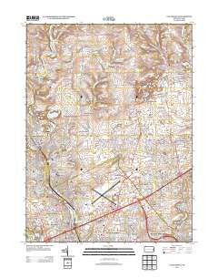
~ Catasauqua PA topo map, 1:24000 scale, 7.5 X 7.5 Minute, Historical, 2013
Catasauqua, Pennsylvania, USGS topographic map dated 2013.
Includes geographic coordinates (latitude and longitude). This topographic map is suitable for hiking, camping, and exploring, or framing it as a wall map.
Printed on-demand using high resolution imagery, on heavy weight and acid free paper, or alternatively on a variety of synthetic materials.
Topos available on paper, Waterproof, Poly, or Tyvek. Usually shipping rolled, unless combined with other folded maps in one order.
- Product Number: USGS-5948175
- Free digital map download (high-resolution, GeoPDF): Catasauqua, Pennsylvania (file size: 27 MB)
- Map Size: please refer to the dimensions of the GeoPDF map above
- Weight (paper map): ca. 55 grams
- Map Type: POD USGS Topographic Map
- Map Series: US Topo
- Map Verison: Historical
- Cell ID: 69575
- Datum: North American Datum of 1983
- Map Projection: Transverse Mercator
- Map Cell Name: Catasauqua
- Grid size: 7.5 X 7.5 Minute
- Date on map: 2013
- Map Scale: 1:24000
- Geographical region: Pennsylvania, United States
Neighboring Maps:
All neighboring USGS topo maps are available for sale online at a variety of scales.
Spatial coverage:
Topo map Catasauqua, Pennsylvania, covers the geographical area associated the following places:
- Clyde - Notre Dame Hills - Beersville - Mickleys - Allen Junction - Hokendauqua - Franks Corner - Newport - Weaversville - Hawktown - Stafore Estates - Coplay - Seemsville - Kreidersville - Westgate Hills - Delta Manor - Chickentown - Schoenersville - West Catasauqua - North Catasauqua - Bath Junction - Shimer - Arlington Knolls - Kaywin - Hanover - Howertown - Lerchs - Catasauqua - Fullerton - Miller Manor - Midway Manor - Dannersville - Jamesville - Bath - Rosemont Terrace - Juniper Circle - Northampton - Evergreen Park - Jacksonville - Nelighsville
- Map Area ID: AREA40.7540.625-75.5-75.375
- Northwest corner Lat/Long code: USGSNW40.75-75.5
- Northeast corner Lat/Long code: USGSNE40.75-75.375
- Southwest corner Lat/Long code: USGSSW40.625-75.5
- Southeast corner Lat/Long code: USGSSE40.625-75.375
- Northern map edge Latitude: 40.75
- Southern map edge Latitude: 40.625
- Western map edge Longitude: -75.5
- Eastern map edge Longitude: -75.375


