
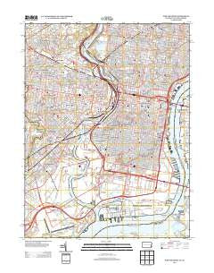
~ Philadelphia PA topo map, 1:24000 scale, 7.5 X 7.5 Minute, Historical, 2013
Philadelphia, Pennsylvania, USGS topographic map dated 2013.
Includes geographic coordinates (latitude and longitude). This topographic map is suitable for hiking, camping, and exploring, or framing it as a wall map.
Printed on-demand using high resolution imagery, on heavy weight and acid free paper, or alternatively on a variety of synthetic materials.
Topos available on paper, Waterproof, Poly, or Tyvek. Usually shipping rolled, unless combined with other folded maps in one order.
- Product Number: USGS-5947577
- Free digital map download (high-resolution, GeoPDF): Philadelphia, Pennsylvania (file size: 31 MB)
- Map Size: please refer to the dimensions of the GeoPDF map above
- Weight (paper map): ca. 55 grams
- Map Type: POD USGS Topographic Map
- Map Series: US Topo
- Map Verison: Historical
- Cell ID: 34953
- Datum: North American Datum of 1983
- Map Projection: Transverse Mercator
- Map Cell Name: Philadelphia
- Grid size: 7.5 X 7.5 Minute
- Date on map: 2013
- Map Scale: 1:24000
- Geographical region: Pennsylvania, United States
Neighboring Maps:
All neighboring USGS topo maps are available for sale online at a variety of scales.
Spatial coverage:
Topo map Philadelphia, Pennsylvania, covers the geographical area associated the following places:
- Olde Kensington - Southwest Center City - Southwest Schuylkill - Sharswood - Girard Estate - Packer Park - Eastwick - Wynnefield - Fishtown - Merion - Cobbs Creek - Haddington - Grays Ferry - Overbrook - West Kensington - Chinatown - Garden Court - Carroll Park - Stenton - Ludlow - Philadelphia - Passyunk Homes - North Central - Angora - Northern Liberties - Spruce Hill - Whitman - Bartram Village - Society Hill - Hawthorne - Rittenhouse - Bala - Queen Village - Poplar - Bell Road (historical) - Tasker Homes - Brewerytown - Fairmount - Hartranft - Mantua - Cardington - Pennsport - Point Breeze - Haddington - Cedar Park - Strawberry Mansion - Schuylkill - Spring Garden - Paschall - Kingsessing - Mill Creek - Belmont - Bella Vista - Elmwood - University City - Francisville - Parkside - Carroll Park - Yorktown - Old City - Kensington - Wharton - Powelton
- Map Area ID: AREA4039.875-75.25-75.125
- Northwest corner Lat/Long code: USGSNW40-75.25
- Northeast corner Lat/Long code: USGSNE40-75.125
- Southwest corner Lat/Long code: USGSSW39.875-75.25
- Southeast corner Lat/Long code: USGSSE39.875-75.125
- Northern map edge Latitude: 40
- Southern map edge Latitude: 39.875
- Western map edge Longitude: -75.25
- Eastern map edge Longitude: -75.125


