
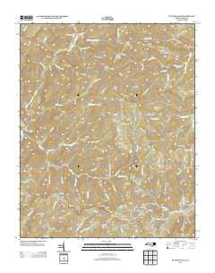
~ Bunches Bald NC topo map, 1:24000 scale, 7.5 X 7.5 Minute, Historical, 2013
Bunches Bald, North Carolina, USGS topographic map dated 2013.
Includes geographic coordinates (latitude and longitude). This topographic map is suitable for hiking, camping, and exploring, or framing it as a wall map.
Printed on-demand using high resolution imagery, on heavy weight and acid free paper, or alternatively on a variety of synthetic materials.
Topos available on paper, Waterproof, Poly, or Tyvek. Usually shipping rolled, unless combined with other folded maps in one order.
- Product Number: USGS-5946786
- Free digital map download (high-resolution, GeoPDF): Bunches Bald, North Carolina (file size: 40 MB)
- Map Size: please refer to the dimensions of the GeoPDF map above
- Weight (paper map): ca. 55 grams
- Map Type: POD USGS Topographic Map
- Map Series: US Topo
- Map Verison: Historical
- Cell ID: 6188
- Datum: North American Datum of 1983
- Map Projection: Transverse Mercator
- Map Cell Name: Bunches Bald
- Grid size: 7.5 X 7.5 Minute
- Date on map: 2013
- Map Scale: 1:24000
- Geographical region: North Carolina, United States
Neighboring Maps:
All neighboring USGS topo maps are available for sale online at a variety of scales.
Spatial coverage:
Topo map Bunches Bald, North Carolina, covers the geographical area associated the following places:
- Wolf Laurel Branch - Horsetrough Ridge Overlook - Quillaree Branch - Round Bottom Creek - Big Cove Mission - Woody Ridge - Messer Fork - Shanty Mountain - Chiltoes Mountain - Rough Ridge - Warm Cove Branch - Wolf Cove Creek - Hurricane Creek - Whim Knob - Maggot Spring Branch - Big Spruce Ridge - Horse Creek - Jenkins Ridge Overlook - Tooni Branch - Mollie Gap - Jonathan Creek Overlook - Left Fork Redman Creek - Chestnut Ridge - Black Camp Gap - Board Cove Branch - Heintooga Overlook - Heintooga Creek - Black Camp Branch - Round Bottom Horse Camp - Balsam Mountain Campground - Strawberry Knob - Lickstone Ridge Tunnel - Mashie Stomp Creek - Horse Creek Gap - Moody Branch - Little Ridge - Chiltoskie Ridge - Garretts Gap - George Ira Creek - Big Witch Tunnel - Indian Creek - Lickstone Overlook - Spread Branch - Spruce Mountain Ridge - Big Witch Gap - Little Bald Branch - Potato Hill Bald - Flat Creek Falls - Soco Bald - Heintooga Ridge - Big Ridge - Big Fork Ridge - Long Branch - Bunches Bald Overlook - Barnett Knob - Pleasant Branch - Brown Lead - Spruce Mountain - Horse Camp - Docks Gap - Locust Knob - Big Witch Overlook - Redman Creek - Hyatt Creek - Maggot Spring Gap - Wycle Fork - Cataloochee Balsam - Big Cove - Bunches Creek - Selma Creek - Flat Creek Campsite - Bear Branch - Straight Fork Raven Fork - Plott Ridge - Sugartree Licks - Heintooga Bald - Polls Gap - Jones Creek - Little Spruce Ridge - Right Prong Ledge Creek - Maggot Ridge - John Henry Camp Creek - Bunches Bald - Masonic Monument - Wolf Laurel Gap - Brushy Gap - Prettyland Mountain - McGhee Cemetery - Plott Balsam Overlook - Stillwell Creek - Skidder Branch - Madcap Branch - Rock Camp Run - Flat Creek - Ledge Creek - Round Bottom Campground - Bunches Gap - Mile High Overlook - Peachtree Church - Flat Bald Branch
- Map Area ID: AREA35.62535.5-83.25-83.125
- Northwest corner Lat/Long code: USGSNW35.625-83.25
- Northeast corner Lat/Long code: USGSNE35.625-83.125
- Southwest corner Lat/Long code: USGSSW35.5-83.25
- Southeast corner Lat/Long code: USGSSE35.5-83.125
- Northern map edge Latitude: 35.625
- Southern map edge Latitude: 35.5
- Western map edge Longitude: -83.25
- Eastern map edge Longitude: -83.125


