
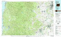
~ Corvallis OR topo map, 1:100000 scale, 30 X 60 Minute, Historical, 1980, updated 1981
Corvallis, Oregon, USGS topographic map dated 1980.
Includes geographic coordinates (latitude and longitude). This topographic map is suitable for hiking, camping, and exploring, or framing it as a wall map.
Printed on-demand using high resolution imagery, on heavy weight and acid free paper, or alternatively on a variety of synthetic materials.
Topos available on paper, Waterproof, Poly, or Tyvek. Usually shipping rolled, unless combined with other folded maps in one order.
- Product Number: USGS-5930909
- Free digital map download (high-resolution, GeoPDF): Corvallis, Oregon (file size: 38 MB)
- Map Size: please refer to the dimensions of the GeoPDF map above
- Weight (paper map): ca. 55 grams
- Map Type: POD USGS Topographic Map
- Map Series: HTMC
- Map Verison: Historical
- Cell ID: 67344
- Scan ID: 283067
- Imprint Year: 1981
- Woodland Tint: Yes
- Aerial Photo Year: 1978
- Edit Year: 1980
- Datum: NAD27
- Map Projection: Universal Transverse Mercator
- Map published by United States Geological Survey
- Keywords: Overedge
- Map Language: English
- Scanner Resolution: 600 dpi
- Map Cell Name: Corvallis
- Grid size: 30 X 60 Minute
- Date on map: 1980
- Map Scale: 1:100000
- Geographical region: Oregon, United States
Neighboring Maps:
All neighboring USGS topo maps are available for sale online at a variety of scales.
Spatial coverage:
Topo map Corvallis, Oregon, covers the geographical area associated the following places:
- Suver - Millersburg - Nashville - Peak (historical) - Harlan - Nortons - Sunnyridge - Flynn - Glen (historical) - Eola - Santiam City (historical) - Rosedale - Kingwood Park (historical) - Calloway (historical) - Sidney - Rickreall - Monmouth - Roberts - Lewisville - Salemtowne - Chitwood - Siletz - Fruitvale - Riverside - Noon - Buena Vista - Keas Corner - West Salem - Salem - Four Cabin Corner - Blodgett - Chapman Corner - Highland Station (historical) - Jefferson - Dry Creek - Dencer (historical) - Parker - Eddyville - Cochrane (historical) - Corvallis - North Albany - Harris - Talbot - Bellamy (historical) - Black Rock - Stapleton - Brush College - Logsden - Pedee - Adair Village - Sunnyside - Modeville - Albany - Little Elk (historical) - Summit - Draperville - Elk City - Bridgeport - Morrison (historical) - Oakdale - Pioneer - Lewisburg - Independence - Fir Villa - Pioneer City (historical) - Liberty - Ellendale - Toledo - Keizer - Tangent - Valsetz (historical) - Hoskins - Ferns (historical) - Wren - Burnt Woods - Philomath - Putnam (historical) - Salem Station (historical) - Kings Valley - Falls City - Bowersville (historical) - Alder - Grabenhorst Corner - Airlie - Carey (historical) - Dallas - Hopville
- Map Area ID: AREA4544.5-124-123
- Northwest corner Lat/Long code: USGSNW45-124
- Northeast corner Lat/Long code: USGSNE45-123
- Southwest corner Lat/Long code: USGSSW44.5-124
- Southeast corner Lat/Long code: USGSSE44.5-123
- Northern map edge Latitude: 45
- Southern map edge Latitude: 44.5
- Western map edge Longitude: -124
- Eastern map edge Longitude: -123


