
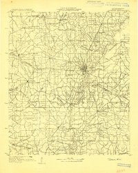
~ Jackson MS topo map, 1:125000 scale, 30 X 30 Minute, Historical, 1903
Jackson, Mississippi, USGS topographic map dated 1903.
Includes geographic coordinates (latitude and longitude). This topographic map is suitable for hiking, camping, and exploring, or framing it as a wall map.
Printed on-demand using high resolution imagery, on heavy weight and acid free paper, or alternatively on a variety of synthetic materials.
Topos available on paper, Waterproof, Poly, or Tyvek. Usually shipping rolled, unless combined with other folded maps in one order.
- Product Number: USGS-5930723
- Free digital map download (high-resolution, GeoPDF): Jackson, Mississippi (file size: 7 MB)
- Map Size: please refer to the dimensions of the GeoPDF map above
- Weight (paper map): ca. 55 grams
- Map Type: POD USGS Topographic Map
- Map Series: HTMC
- Map Verison: Historical
- Cell ID: 396098
- Scan ID: 337250
- Survey Year: 1903
- Datum: Unstated
- Map Projection: Unstated
- Advance: Yes
- Planimetric: Yes
- Map published by United States Geological Survey
- Keywords: Nonstandard Press Run
- Map Language: English
- Scanner Resolution: 600 dpi
- Map Cell Name: Jackson
- Grid size: 30 X 30 Minute
- Date on map: 1903
- Map Scale: 1:125000
- Geographical region: Mississippi, United States
Neighboring Maps:
All neighboring USGS topo maps are available for sale online at a variety of scales.
Spatial coverage:
Topo map Jackson, Mississippi, covers the geographical area associated the following places:
- Bolton - Florence - Huntcliff - Brookhollow Place - McLaurin Heights - King - Midway - Mill Creek - Queens Lane - Bernard - Madison - Gary Estates - Western Hills - Lakeland - New Hope Grove - Woodmoor - Alonzo - Rosemary - Hope Springs - North Town Plaza - Hickory Glen - New Byram - Forest Hill - Northwest Hills - Siwel - Roses Bluff - Lost Lake - Pearl - Carriage Hills - Pelahatchie Woods - Highland Meadows - Treasure Cove - Natchez Trace Village - Howell (historical) - Greenbrook - Windsor Forest - Tinnin - Plainview - Spring Ridge - Skyway Hills - Melvin Heights - Woodhaven - Briarcliff - The Cascades - Hunters Creek - Comeby (historical) - Bradie - Hunters Woods - Country Place - Wells - Palestine - Dry Grove - Shadow Lake Estates - Twelve Oaks - Pine Park - Presidential Hills - Dixon Acres - Bates Park - Summerwood - Linden (historical) - Cleary Heights - Wateroaks - Pearson - Cedar Hill - Beaver Creek - Brookwood Pines - Easthaven - Country Woods - Harperville (historical) - Moncure - Forest Green - Belaire - Ridgeland - Wingfield Place - Turtle Creek - Paradise Point - Brownsville - Morgans Store - Meadowhill - Brookwood - Lakeside - Clinton - Leavell woods - Van Winkle - Whites - Oak Creek - Pine Lea - Dabney Crossroads - Bridlewood - Pine Grove - Forest Point - Gaylyn Terrace - Pocahontas - Terry - Byrd Heights - Clear Branch - Mayfair - Dogwood Place - Egypt Hill - Jackson
- Map Area ID: AREA32.532-90.5-90
- Northwest corner Lat/Long code: USGSNW32.5-90.5
- Northeast corner Lat/Long code: USGSNE32.5-90
- Southwest corner Lat/Long code: USGSSW32-90.5
- Southeast corner Lat/Long code: USGSSE32-90
- Northern map edge Latitude: 32.5
- Southern map edge Latitude: 32
- Western map edge Longitude: -90.5
- Eastern map edge Longitude: -90


