
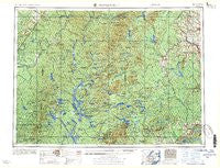
~ Presque Isle ME topo map, 1:250000 scale, 1 X 2 Degree, Historical, 1958, updated 1958
Presque Isle, Maine, USGS topographic map dated 1958.
Includes geographic coordinates (latitude and longitude). This topographic map is suitable for hiking, camping, and exploring, or framing it as a wall map.
Printed on-demand using high resolution imagery, on heavy weight and acid free paper, or alternatively on a variety of synthetic materials.
Topos available on paper, Waterproof, Poly, or Tyvek. Usually shipping rolled, unless combined with other folded maps in one order.
- Product Number: USGS-5930657
- Free digital map download (high-resolution, GeoPDF): Presque Isle, Maine (file size: 31 MB)
- Map Size: please refer to the dimensions of the GeoPDF map above
- Weight (paper map): ca. 55 grams
- Map Type: POD USGS Topographic Map
- Map Series: HTMC
- Map Verison: Historical
- Cell ID: 68973
- Scan ID: 460779
- Imprint Year: 1958
- Woodland Tint: Yes
- Field Check Year: 1954
- Datum: Unstated
- Map Projection: Transverse Mercator
- Map published by United States Army Corps of Engineers
- Map published by United States Army
- Map Language: English
- Scanner Resolution: 600 dpi
- Map Cell Name: Presque Isle
- Grid size: 1 X 2 Degree
- Date on map: 1958
- Map Scale: 1:250000
- Geographical region: Maine, United States
Neighboring Maps:
All neighboring USGS topo maps are available for sale online at a variety of scales.
Spatial coverage:
Topo map Presque Isle, Maine, covers the geographical area associated the following places:
- Griswold - Pauls - New Sweden - Blackwater - Rand Landing - Halls Corner - Little Canada - Mapleton - Bennett - Hillman - Colby - Clayton Lake - Hanford - Grassy Landing - Barretts - Rands - Dyer Brook - Pine Knoll - Bugbee - Wheelock Mill - Spragueville - The Crossing - Oakfield - Sheridan - Moro - Nixon - Quimby - Crouseville - Knowles Corner - McNally - Grindstone - Margison - McKeen Crossing - Shin Pond - Dudley - Blackstone - Hawkins - Moosehorn Crossing - Caribou - Scopan - Timoney - Frenchville - Smyrna Mills - Shorey - Portage - Howe Brook - Pride - Presque Isle - New Sweden Station - Lac Frontiere - Batesville - Oxbow - Winterville - Smyrna Center - Round Mountain - Sweden - Island Falls - Adaline - Perham - Huson Landing - Chesuncook - Acadia - Weeksboro - Woodland Center - North Wade - Buffalo - Presque Isle Junction - State Road - Ludlow - Carson - Skerry - Masardis - Spaulding - Ashland - Walker - Walker Settlement - High Landing - Deadmans Corner - Chapman - Russell Crossing - North Lyndon - Hersey - McCarty - Washburn - Greenlaw Crossing - Ogren - Old City
- Map Area ID: AREA4746-70-68
- Northwest corner Lat/Long code: USGSNW47-70
- Northeast corner Lat/Long code: USGSNE47-68
- Southwest corner Lat/Long code: USGSSW46-70
- Southeast corner Lat/Long code: USGSSE46-68
- Northern map edge Latitude: 47
- Southern map edge Latitude: 46
- Western map edge Longitude: -70
- Eastern map edge Longitude: -68


