
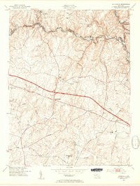
~ Sykesville MD topo map, 1:24000 scale, 7.5 X 7.5 Minute, Historical, 1953, updated 1954
Sykesville, Maryland, USGS topographic map dated 1953.
Includes geographic coordinates (latitude and longitude). This topographic map is suitable for hiking, camping, and exploring, or framing it as a wall map.
Printed on-demand using high resolution imagery, on heavy weight and acid free paper, or alternatively on a variety of synthetic materials.
Topos available on paper, Waterproof, Poly, or Tyvek. Usually shipping rolled, unless combined with other folded maps in one order.
- Product Number: USGS-5930617
- Free digital map download (high-resolution, GeoPDF): Sykesville, Maryland (file size: 11 MB)
- Map Size: please refer to the dimensions of the GeoPDF map above
- Weight (paper map): ca. 55 grams
- Map Type: POD USGS Topographic Map
- Map Series: HTMC
- Map Verison: Historical
- Cell ID: 44075
- Scan ID: 461501
- Imprint Year: 1954
- Aerial Photo Year: 1943
- Datum: NAD27
- Map Projection: Polyconic
- Map published by United States Geological Survey
- Map published by United States Army Corps of Engineers
- Map Language: English
- Scanner Resolution: 600 dpi
- Map Cell Name: Sykesville
- Grid size: 7.5 X 7.5 Minute
- Date on map: 1953
- Map Scale: 1:24000
- Geographical region: Maryland, United States
Neighboring Maps:
All neighboring USGS topo maps are available for sale online at a variety of scales.
Spatial coverage:
Topo map Sykesville, Maryland, covers the geographical area associated the following places:
- The Corners - Ridgeways - Gorsuch (historical) - Lexington Run - Timberleigh - Briar Hill - West Friendship - Bloomfield Manor - Gaither Manor - Eazee Acres - Heritage Farms - Brosenne - Patapsco Estates - Annandale - Kingston - Locust Ridge - Westcliffe Manor - Amberly - Indian Hill - Clarkson - Triadelphia Woods - Berndell Estates - Buttercup Estates - Valley Anne Estates - Gaither - Henryton Heights - Driver - Buckskin Woods - Breezewood Farms - Albeth Heights - Turf Valley - Gaither Heights - Wayside Estates - Friendship Manor - Slacks Corner - Mayfield - River Park Estates - Crest Acres - Rover (historical) - Oakwood Overlook - Glenelg - Eagles Loft - Prospect Hills - Rose Mary Estates - Heatherwood - Shannon Run - Sand Hill Acres - Sycamore Springs - Carroll Fields - Cameron Tract - Gerber Knoll - Burnt Woods - Ivory - Wynfield - Sykesville - Everlea - Sandy Hill - Shepherds Glen - Alpha - Benson - Donghoregan - Salopha - Mountview - Woodmark - Evergreen Valley Estates - Green Henge - Fox Den Farms - Marriottsville - Henryton
- Map Area ID: AREA39.37539.25-77-76.875
- Northwest corner Lat/Long code: USGSNW39.375-77
- Northeast corner Lat/Long code: USGSNE39.375-76.875
- Southwest corner Lat/Long code: USGSSW39.25-77
- Southeast corner Lat/Long code: USGSSE39.25-76.875
- Northern map edge Latitude: 39.375
- Southern map edge Latitude: 39.25
- Western map edge Longitude: -77
- Eastern map edge Longitude: -76.875


