
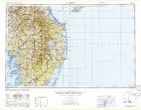
~ Salisbury MD topo map, 1:250000 scale, 1 X 2 Degree, Historical, 1947, updated 1948
Salisbury, Maryland, USGS topographic map dated 1947.
Includes geographic coordinates (latitude and longitude). This topographic map is suitable for hiking, camping, and exploring, or framing it as a wall map.
Printed on-demand using high resolution imagery, on heavy weight and acid free paper, or alternatively on a variety of synthetic materials.
Topos available on paper, Waterproof, Poly, or Tyvek. Usually shipping rolled, unless combined with other folded maps in one order.
- Product Number: USGS-5930581
- Free digital map download (high-resolution, GeoPDF): Salisbury, Maryland (file size: 17 MB)
- Map Size: please refer to the dimensions of the GeoPDF map above
- Weight (paper map): ca. 55 grams
- Map Type: POD USGS Topographic Map
- Map Series: HTMC
- Map Verison: Historical
- Cell ID: 74990
- Scan ID: 461481
- Imprint Year: 1948
- Woodland Tint: Yes
- Datum: NAD27
- Map Projection: Transverse Mercator
- Map published by United States Geological Survey
- Map Language: English
- Scanner Resolution: 600 dpi
- Map Cell Name: Salisbury
- Grid size: 1 X 2 Degree
- Date on map: 1947
- Map Scale: 1:250000
- Geographical region: Maryland, United States
Neighboring Maps:
All neighboring USGS topo maps are available for sale online at a variety of scales.
Spatial coverage:
Topo map Salisbury, Maryland, covers the geographical area associated the following places:
- Moss Hill Acres - Nanticoke Acres - Dills Acres - Ward - Blackwater Cove - Bayville - Kaywood - Nottingham Woods - Mill Creek Manor - Williamsville - Holiday Estates - Vienna - Colonial Acres - Waljacks Corners - The Oaks - Nithsdale - West Haven - Hurlock - Sand Dunes Village - Dogwood Acres - Bayside Keys - Hickory Hill - Cloverdale Farm - Foxchase - Fox Field - Sunayr - Horseshoe Estates - Westlake - Shawns Hideaway Mobile Home Park - Beaver Run Mobile Home Park - Morris Mill - Hall Estates - Jonestown - Stanley Manor - Jersey Road Estates - Prettyman Manor - Hickman - The Landing - Fox Run Mobile Home Park - Holly Leaf Estates Mobile Home Park - Southside Trailer Park - Trappe - Silver View Farm - Wellington Estates - Bank Harbor Retreat - Woodenhawk Pines - Houston - Sunset Beach - Woods Edge - Ferry Landing - Meadow Manor - Henlopen Acres - Hawkeye - Landon Station - Coverdale Crossroads - Cuelen Acres - Careys Estate Mobile Home Park - Nanticoke - Sandy Brae - Pondside Acres - Sassafras Landing - Oak Orchard West Mobile Home Park - George Island Landing - Johnson - Fairfield - Irons Lane Landing - Whiton - Summit - Harrington - Park Manor - Tri-State Mobile Home Park - Newport - Belmont Acres - New Hope - Whaleys Corners - Wenona - Church Hill Village - Wescoats Corner - Indian Landing North Mobile Home Park - Federalsburg Estates - Frankford - Northwood - Grenada Manor - Indian Harbor Villa - Deerfield - Snow Hill - Danwood - Midway Park Subdivision - Evans Park Mobile Home Park - Green Hill Village - Wildwood Gables - Trinity - Belltown - Berlin - Andersons Corner - Kings Grant - Land of Pleasant Living - Angola Crest II Mobile Home Park - Roxana - Reids Grove
- Map Area ID: AREA3938-76-74
- Northwest corner Lat/Long code: USGSNW39-76
- Northeast corner Lat/Long code: USGSNE39-74
- Southwest corner Lat/Long code: USGSSW38-76
- Southeast corner Lat/Long code: USGSSE38-74
- Northern map edge Latitude: 39
- Southern map edge Latitude: 38
- Western map edge Longitude: -76
- Eastern map edge Longitude: -74


