
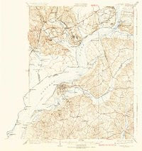
~ Indian Head MD topo map, 1:62500 scale, 15 X 15 Minute, Historical, 1925, updated 1925
Indian Head, Maryland, USGS topographic map dated 1925.
Includes geographic coordinates (latitude and longitude). This topographic map is suitable for hiking, camping, and exploring, or framing it as a wall map.
Printed on-demand using high resolution imagery, on heavy weight and acid free paper, or alternatively on a variety of synthetic materials.
Topos available on paper, Waterproof, Poly, or Tyvek. Usually shipping rolled, unless combined with other folded maps in one order.
- Product Number: USGS-5930425
- Free digital map download (high-resolution, GeoPDF): Indian Head, Maryland (file size: 8 MB)
- Map Size: please refer to the dimensions of the GeoPDF map above
- Weight (paper map): ca. 55 grams
- Map Type: POD USGS Topographic Map
- Map Series: HTMC
- Map Verison: Historical
- Cell ID: 55740
- Scan ID: 461532
- Imprint Year: 1925
- Survey Year: 1923
- Datum: NAD
- Map Projection: Polyconic
- Map published by United States Geological Survey
- Keywords: Overedge
- Map Language: English
- Scanner Resolution: 600 dpi
- Map Cell Name: Indian Head
- Grid size: 15 X 15 Minute
- Date on map: 1925
- Map Scale: 1:62500
- Geographical region: Maryland, United States
Neighboring Maps:
All neighboring USGS topo maps are available for sale online at a variety of scales.
Spatial coverage:
Topo map Indian Head, Maryland, covers the geographical area associated the following places:
- Du-Mar Estates - Wiley - Lorton - Laurel Branch - Snowden - Wessynton - Accokeek - Auburn - Colchester - Knotts Crossing - Waynewood - Countryside - South Hampton Village - Oakwood - Fenwick - Strawberry Hills Estates - Gum Springs - Calvert Manor - Hunter Estates - Pomfret Estates - Farmington Road Estates - Woodley Hills - Hybla Valley - Woodbridge - Bellevue Estates - Port Tobacco Riviera - Chicamuxen - Springfield Oaks - Harbor View - McConchie - Riverside Estates - Marshalls Corner - Tarrington Creek - Green Meadows - Battersea on the Bay - McGhiesport - Pomfret - Rison - Accokeek Lawn - Yacht Haven - Tauxenent (historical) - Marbury - Tantallon North - Kimberly Woods - Woodlawn - Stratford Landing - Mount Carmel - Berry Hill Manor - Nelson - Chapel Acres - Village of Mount Air - Fenwick Shores - Hawthorne - Tantallon Hills - Pohick - Rollingwood - Avon Crest - Redhill - Raceway Farms - Garden Estates - Port Tobacco Hills - Bennsville - Myrtle Grove Estates - Mount Pisgah - Millards Mill - Schuyler Hills - Featherstone Shores - River Bend Estates - Bryans Road - Valley View - Bayside Park - Fort Hunt - Charleston Gardens - Tantallon Square - Sulgrave Manor - Tantallon - Smallwood Estates - Ripley - Woodland Park - Ayres - Riverview Estates - Bryan Point - Stratford on the Potomac - Columbia Park - Indian Head - Newberry Station - Oakwood - Waldon Woods - North Indian Head Estates - Woodlawn Manor - Redhill Estates - King George Estates - Warington Hills - Belmont Park - Foxhall Estates - Billingsley Forest - Riverwood - Mount Vernon Woods - Belle Rive - Chapman Landing
- Map Area ID: AREA38.7538.5-77.25-77
- Northwest corner Lat/Long code: USGSNW38.75-77.25
- Northeast corner Lat/Long code: USGSNE38.75-77
- Southwest corner Lat/Long code: USGSSW38.5-77.25
- Southeast corner Lat/Long code: USGSSE38.5-77
- Northern map edge Latitude: 38.75
- Southern map edge Latitude: 38.5
- Western map edge Longitude: -77.25
- Eastern map edge Longitude: -77


