
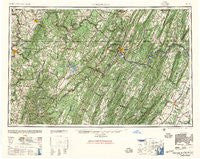
~ Cumberland MD topo map, 1:250000 scale, 1 X 2 Degree, Historical, 1948, updated 1957
Cumberland, Maryland, USGS topographic map dated 1948.
Includes geographic coordinates (latitude and longitude). This topographic map is suitable for hiking, camping, and exploring, or framing it as a wall map.
Printed on-demand using high resolution imagery, on heavy weight and acid free paper, or alternatively on a variety of synthetic materials.
Topos available on paper, Waterproof, Poly, or Tyvek. Usually shipping rolled, unless combined with other folded maps in one order.
- Product Number: USGS-5930317
- Free digital map download (high-resolution, GeoPDF): Cumberland, Maryland (file size: 29 MB)
- Map Size: please refer to the dimensions of the GeoPDF map above
- Weight (paper map): ca. 55 grams
- Map Type: POD USGS Topographic Map
- Map Series: HTMC
- Map Verison: Historical
- Cell ID: 68734
- Scan ID: 461592
- Imprint Year: 1957
- Woodland Tint: Yes
- Aerial Photo Year: 1944
- Datum: NAD27
- Map Projection: Transverse Mercator
- Map published by United States Geological Survey
- Map Language: English
- Scanner Resolution: 600 dpi
- Map Cell Name: Cumberland
- Grid size: 1 X 2 Degree
- Date on map: 1948
- Map Scale: 1:250000
- Geographical region: Maryland, United States
Neighboring Maps:
All neighboring USGS topo maps are available for sale online at a variety of scales.
Spatial coverage:
Topo map Cumberland, Maryland, covers the geographical area associated the following places:
- Sedan - Friendship Heights - Stephens City - Masontown - Valley (historical) - Oak Hill - Penn Pitt - Mount Sterling - Mount Savage Junction - Oldtown - McKenzie - Braddock Hills Estates - Millbrook - Skipnish (historical) - Lemont Furnace - Borden Shaft - Meadow Mills - Woodburn - Dugan Hill - Southview - Unger - Barrelville - Penncraft - Grantsville - Tower Hill Number One - Reynolds - North Mountain Estates - Clifton Mills - Covalt - Shober - Burning Bush - Mexico - Collinsville - Burning Knolls - Puritan - West Bend - Ruckman - McCauley - Philson - Buffington - Wilsonia (historical) - Greenland - Montrose - Smith Crossroads - Juniata - Shiloh (historical) - Fossilville - Pyletown - Charlestown - Pleasant Run - Doe Gully - Apple View Estates - Marlboro - Bedford Springs - Sell - Saint Paul - Short Gap - Clary - Niver Junction - Amboy - Mountain View Acres - Hendricks - Paddytown - Percy - Park Head - Brookhaven - Normalville - Reliance - Wadesville - Salco - Higginsville - Browns Mill - Accident - Brady - Schweibinzville - Hogsett - Franklin - Gibbon Glade - Hardesty - Harvey - Oliphant Furnace - Fairmor - Whitacre - Shoaf - Lashley - Humbert - Lap - Fort Ashby - Rock Oak - Cardale - Little Summit - Wiles Hill - Greenway Estates - Danville - Dent - Roberts - Sulphur Springs - Day - Mar Village - South Cumberland - Barnes Gap
- Map Area ID: AREA4039-80-78
- Northwest corner Lat/Long code: USGSNW40-80
- Northeast corner Lat/Long code: USGSNE40-78
- Southwest corner Lat/Long code: USGSSW39-80
- Southeast corner Lat/Long code: USGSSE39-78
- Northern map edge Latitude: 40
- Southern map edge Latitude: 39
- Western map edge Longitude: -80
- Eastern map edge Longitude: -78


