
~ Cumberland MD topo map, 1:250000 scale, 1 X 2 Degree, Historical, 1956, updated 1966
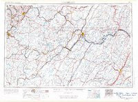
Cumberland, Maryland, USGS topographic map dated 1956.
Includes geographic coordinates (latitude and longitude). This topographic map is suitable for hiking, camping, and exploring, or framing it as a wall map.
Printed on-demand using high resolution imagery, on heavy weight and acid free paper, or alternatively on a variety of synthetic materials.
Topos available on paper, Waterproof, Poly, or Tyvek. Usually shipping rolled, unless combined with other folded maps in one order.
- Product Number: USGS-5930307
- Free digital map download (high-resolution, GeoPDF): Cumberland, Maryland (file size: 16 MB)
- Map Size: please refer to the dimensions of the GeoPDF map above
- Weight (paper map): ca. 55 grams
- Map Type: POD USGS Topographic Map
- Map Series: HTMC
- Map Verison: Historical
- Cell ID: 68734
- Scan ID: 461421
- Imprint Year: 1966
- Field Check Year: 1956
- Datum: Unstated
- Map Projection: Transverse Mercator
- Planimetric: Yes
- Special Map: Yes
- Map published by United States Army Corps of Engineers
- Map published by United States Army
- Map Language: English
- Scanner Resolution: 600 dpi
- Map Cell Name: Cumberland
- Grid size: 1 X 2 Degree
- Date on map: 1956
- Map Scale: 1:250000
- Geographical region: Maryland, United States
Neighboring Maps:
All neighboring USGS topo maps are available for sale online at a variety of scales.
Spatial coverage:
Topo map Cumberland, Maryland, covers the geographical area associated the following places:
- Brown Row - Myersdale - Barnum - Shenandoah Mobile Home Park - Warnocks - Orient - West Vindex - Lap - Upper Middletown - Masontown - Grimes - Nain - Millen - Bidwell - Stewarton - Town Creek - Lincoln Estates - Gilmore - Mountain Vistas - Okonoko - Mapleton (historical) - Arthurdale - Cranesville - Texas (historical) - Rices Landing - Rowlesburg - Dellslow - Amblersburg - Carmel - Kegg - Ernstville - McCauley - Cecil - Bier - Rosendorf - Chestnut Ridge - Stewartstown - Wildwood Hills - Rock Hall - Hill Crest - Buena (historical) - Crucible - Greensboro - Armel - Asher Glade - Thompson Number 2 - Brookneil - Smith Crossroads - Laurel Hill - Woodland - Richford (historical) - North Branch - Shoaf - Middletown - Green Glade - Berlin - Crellin - Dobbin - Pisgah - Concord - Berrett (historical) - Sigsbee - Deer Park - Wagoner - Smock - Burnt Factory - Fairhope - Benbush - Points - Dogwood Flats - Champwood - Clear Brook - Allison - Pechin - Macdonaldton - Lenox - Brewer Hill - Rocks Works - Wallman - Chestnut Grove Estates - Elk Park - Maple Run - Pineridge North - Meyersdale - Morantown - Roxbury - Dickens - Meadow - Niver Junction - Chadville - Arensburg - Gravel Hill - Cross Junction - South Hills - Austen - Huston - East Millsboro - Blue Hill - Greenland - Buck Valley
- Map Area ID: AREA4039-80-78
- Northwest corner Lat/Long code: USGSNW40-80
- Northeast corner Lat/Long code: USGSNE40-78
- Southwest corner Lat/Long code: USGSSW39-80
- Southeast corner Lat/Long code: USGSSE39-78
- Northern map edge Latitude: 40
- Southern map edge Latitude: 39
- Western map edge Longitude: -80
- Eastern map edge Longitude: -78


