
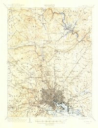
~ Baltimore MD topo map, 1:62500 scale, 15 X 15 Minute, Historical, 1904, updated 1947
Baltimore, Maryland, USGS topographic map dated 1904.
Includes geographic coordinates (latitude and longitude). This topographic map is suitable for hiking, camping, and exploring, or framing it as a wall map.
Printed on-demand using high resolution imagery, on heavy weight and acid free paper, or alternatively on a variety of synthetic materials.
Topos available on paper, Waterproof, Poly, or Tyvek. Usually shipping rolled, unless combined with other folded maps in one order.
- Product Number: USGS-5930225
- Free digital map download (high-resolution, GeoPDF): Baltimore, Maryland (file size: 8 MB)
- Map Size: please refer to the dimensions of the GeoPDF map above
- Weight (paper map): ca. 55 grams
- Map Type: POD USGS Topographic Map
- Map Series: HTMC
- Map Verison: Historical
- Cell ID: 50921
- Scan ID: 461349
- Imprint Year: 1947
- Survey Year: 1902
- Datum: Unstated
- Map Projection: Polyconic
- Map published by United States Geological Survey
- Map Language: English
- Scanner Resolution: 600 dpi
- Map Cell Name: Baltimore
- Grid size: 15 X 15 Minute
- Date on map: 1904
- Map Scale: 1:62500
- Geographical region: Maryland, United States
Neighboring Maps:
All neighboring USGS topo maps are available for sale online at a variety of scales.
Spatial coverage:
Topo map Baltimore, Maryland, covers the geographical area associated the following places:
- Glenmont - Glenmore Park - Brooklandville - Van Dyke Manor - Milestone Manor - Guilford - Colgate Creek - Northampton - Baltimore - Hampton East - Eccleston - Stoneleigh - Rockland Run - Roland Park - Campus Hills - The Willows of Ruxton - Brightwood - Orchard Hills - Brooklandwood Estates - Cylburn (historical) - Velvet Ridge - Waterspout - Hunting Ridge - Cloisters - Marlywood - Towson - Homeland - Britinay Hills - West Glen - Windemere - Loch Hill - Hillside Hunt - Westowne - Gardenville - Cub Hill Farms - Murray Hill - Ruxton - Knoll Acres - Academy Heights - Dixon Hill - Broadmoor - Springlake - Bloomsbury - Chapel Hill - Haver Hill - Bonnie Ridge - Hampden - Oakleigh - Ashland - Villa Cresta - Wilhelm Park - Dulaney Hills - Forest Park - Hunt Valley - Holland Hills - Springhill Farms - Bare Hills - Colgate - Cloverfield Manor - Notch Cliff - Knoebel - Westview Park - Belmar - Mount Vernon - Knettishall - Dulaney Village - Fells Point - Hamilton - Goodnow Hill - Fulton - North Wind - Sorrento Run - Charlestown - High Point - Cub Hill - Deer Woods - Woodbrook - Timonium Heights - Sugarvale Estates - Greenwood - Harford Hills - College Hills - Kenilworth Park - Butchers Hill - Valley North - Catonsville - Fallstaff - Rolling Road Farms - Mount Clare - Norwood Park - Worthington Greens - Hollins (historical) - Kings Ridge - Rogers (historical) - Ivy Hill - Pot Spring - Orangeville - Boxwood - Baronet Woods - Satyr Hill Estates
- Map Area ID: AREA39.539.25-76.75-76.5
- Northwest corner Lat/Long code: USGSNW39.5-76.75
- Northeast corner Lat/Long code: USGSNE39.5-76.5
- Southwest corner Lat/Long code: USGSSW39.25-76.75
- Southeast corner Lat/Long code: USGSSE39.25-76.5
- Northern map edge Latitude: 39.5
- Southern map edge Latitude: 39.25
- Western map edge Longitude: -76.75
- Eastern map edge Longitude: -76.5


