
~ Baltimore MD topo map, 1:250000 scale, 1 X 2 Degree, Historical, 1957, updated 1964
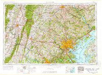
Baltimore, Maryland, USGS topographic map dated 1957.
Includes geographic coordinates (latitude and longitude). This topographic map is suitable for hiking, camping, and exploring, or framing it as a wall map.
Printed on-demand using high resolution imagery, on heavy weight and acid free paper, or alternatively on a variety of synthetic materials.
Topos available on paper, Waterproof, Poly, or Tyvek. Usually shipping rolled, unless combined with other folded maps in one order.
- Product Number: USGS-5930219
- Free digital map download (high-resolution, GeoPDF): Baltimore, Maryland (file size: 24 MB)
- Map Size: please refer to the dimensions of the GeoPDF map above
- Weight (paper map): ca. 55 grams
- Map Type: POD USGS Topographic Map
- Map Series: HTMC
- Map Verison: Historical
- Cell ID: 74996
- Scan ID: 461345
- Imprint Year: 1964
- Woodland Tint: Yes
- Field Check Year: 1957
- Datum: Unstated
- Map Projection: Transverse Mercator
- Map published by United States Geological Survey
- Map published by United States Army Corps of Engineers
- Map published by United States Army
- Map Language: English
- Scanner Resolution: 600 dpi
- Map Cell Name: Baltimore
- Grid size: 1 X 2 Degree
- Date on map: 1957
- Map Scale: 1:250000
- Geographical region: Maryland, United States
Neighboring Maps:
All neighboring USGS topo maps are available for sale online at a variety of scales.
Spatial coverage:
Topo map Baltimore, Maryland, covers the geographical area associated the following places:
- Granite Knoll Farms - Iron Springs - Hunting Lodge - Greengate - Rosemont - Cockeysville - Whitehall Manor - Mount Airy - Robinson - Severn Forest - Lapidum - Hunters Run - Catonsville - Patchwork Farms - Tuscarora Knolls - Montgomery Village - Connecticut Avenue Park - The Pond - Shannon Forest - Long Reach - Carroll County Trails - Arundel Gardens - Corns Manor - Somerset - Olacin - North Springbrook - Stonewall Manor Estates - Sun Set Knoll - Martin - Chase Eden - Pleasant Grove - Pioneer Hills - Buckingham Hills - Worthington Park - Candlewick - Beetree Manor - Walpers Cross-Roads - Winpenny Tell - Heritage Estates - Forest Glen - Charlton - Eagle View - Bayside Village - Woodbridge - McPherson - Ashburn - Parliament Ridge - Pylesville - Montgomery Run - White Oak Manor - Powhatan - Little Acres - Eagle Hill - Coffman - Milford - Northwood Estates - Farquhar Estates - Wayside Estates - Deer Park - Glenmore - Allanwood - Kirks Mills - Pleasant View - Redbridge - Beachmont Estates - Henley Park - Monocacy (historical) - Port Deposit - Victory Villa - Edgewood - Spring Valley Mobile Home Park - Knollwood - Lake Shore - Avondale - Carroll Heights - Castle Oaks - Perry Hall - Kings Manor - Correlli Estates - Warwick - Delight - Fairway - Dunwood - Sunrise - Aylor - West Bangor - Thompson Estates - Shawnee Estates - Woodlawn Mobile Home Estates - Maple Hill Mobile Home Park - Ramona Beach - Clemens Crossing - Vantage Point - Thomasville - Greene Tree - Upper Crossroads - Green Hill Manor - Cider Barrel Motor Home Court (historical) - Eastwick - Barrington Woods
- Map Area ID: AREA4039-78-76
- Northwest corner Lat/Long code: USGSNW40-78
- Northeast corner Lat/Long code: USGSNE40-76
- Southwest corner Lat/Long code: USGSSW39-78
- Southeast corner Lat/Long code: USGSSE39-76
- Northern map edge Latitude: 40
- Southern map edge Latitude: 39
- Western map edge Longitude: -78
- Eastern map edge Longitude: -76


