
~ Shreveport LA topo map, 1:250000 scale, 1 X 2 Degree, Historical, 1955, updated 1955
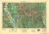
Shreveport, Louisiana, USGS topographic map dated 1955.
Includes geographic coordinates (latitude and longitude). This topographic map is suitable for hiking, camping, and exploring, or framing it as a wall map.
Printed on-demand using high resolution imagery, on heavy weight and acid free paper, or alternatively on a variety of synthetic materials.
Topos available on paper, Waterproof, Poly, or Tyvek. Usually shipping rolled, unless combined with other folded maps in one order.
- Product Number: USGS-5930191
- Free digital map download (high-resolution, GeoPDF): Shreveport, Louisiana (file size: 21 MB)
- Map Size: please refer to the dimensions of the GeoPDF map above
- Weight (paper map): ca. 55 grams
- Map Type: POD USGS Topographic Map
- Map Series: HTMC
- Map Verison: Historical
- Cell ID: 69030
- Scan ID: 707612
- Imprint Year: 1955
- Woodland Tint: Yes
- Field Check Year: 1955
- Datum: Unstated
- Map Projection: Transverse Mercator
- Map published by United States Army Corps of Engineers
- Map published by United States Army
- Map Language: English
- Scanner Resolution: 508 dpi
- Map Cell Name: Shreveport
- Grid size: 1 X 2 Degree
- Date on map: 1955
- Map Scale: 1:250000
- Geographical region: Louisiana, United States
Neighboring Maps:
All neighboring USGS topo maps are available for sale online at a variety of scales.
Spatial coverage:
Topo map Shreveport, Louisiana, covers the geographical area associated the following places:
- Gansville - Randolph - The Meadows - Rosewood Estates - Belle Meade - Manning (historical) - Hammell (historical) - Kickapoo - Dogwood Park - Red Chute - Womack - North Club Estates - De Broeck Landing - Oxbow - Tall Timbers - Blackburn - Chestnut - Howard - Timothy (historical) - Shadow Pine Estates - Myatt (historical) - West Sterlington - Old Athens - Blume - Lucky - Carterville - Chateau Village - Downsville - Midway - Alabama Landing - Spring Ridge - Haynesville - Barso - Walnut Lane (historical) - Sicard - Fryeburg - Edgewood Village - Hunt - Fairway Forest - Mayers - Mimosa Gardens - Placid (historical) - Liberty Hill - Shady - Parkwood - Cherry Ridge (historical) - Siegle - Carmel - Fairbanks - Cadeville - Cynthia Park - County Side - Fairfield - Pratt - Baccus - Antioch - Evergreen - Sligo - Wemple - Bodcau - Forest Grove - Methvin - Lamkin - Quitman - Pine Forest South - Breard - Wilhite - Southgate Estates - Cypress - Guthrie - Aycock - Pine Hill Subdivision - Ebenezer - Quail Ridge - Pickett - Haughton - Merrywoods - Longwood - Sadie - Cavett - Kingston - Southdowns - Ringgold - Bellevue - Bellevue - Shenandoah - Coushatta - Mount Union - Hosston - Averit (historical) - West Gate Terrace - Brookhaven Estates - Jamestown - Skidder - Athens - North Hodge - Culbertson - Mahan - Summerfield - Sunshine Heights
- Map Area ID: AREA3332-94-92
- Northwest corner Lat/Long code: USGSNW33-94
- Northeast corner Lat/Long code: USGSNE33-92
- Southwest corner Lat/Long code: USGSSW32-94
- Southeast corner Lat/Long code: USGSSE32-92
- Northern map edge Latitude: 33
- Southern map edge Latitude: 32
- Western map edge Longitude: -94
- Eastern map edge Longitude: -92


