
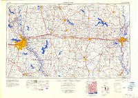
~ Shreveport LA topo map, 1:250000 scale, 1 X 2 Degree, Historical, 1984, updated 1984
Shreveport, Louisiana, USGS topographic map dated 1984.
Includes geographic coordinates (latitude and longitude). This topographic map is suitable for hiking, camping, and exploring, or framing it as a wall map.
Printed on-demand using high resolution imagery, on heavy weight and acid free paper, or alternatively on a variety of synthetic materials.
Topos available on paper, Waterproof, Poly, or Tyvek. Usually shipping rolled, unless combined with other folded maps in one order.
- Product Number: USGS-5930187
- Free digital map download (high-resolution, GeoPDF): Shreveport, Louisiana (file size: 13 MB)
- Map Size: please refer to the dimensions of the GeoPDF map above
- Weight (paper map): ca. 55 grams
- Map Type: POD USGS Topographic Map
- Map Series: HTMC
- Map Verison: Historical
- Cell ID: 69030
- Scan ID: 707610
- Imprint Year: 1984
- Datum: Unstated
- Map Projection: Transverse Mercator
- Planimetric: Yes
- Map published by United States Army Corps of Engineers
- Map published by United States Army
- Map Language: English
- Scanner Resolution: 508 dpi
- Map Cell Name: Shreveport
- Grid size: 1 X 2 Degree
- Date on map: 1984
- Map Scale: 1:250000
- Geographical region: Louisiana, United States
Neighboring Maps:
All neighboring USGS topo maps are available for sale online at a variety of scales.
Spatial coverage:
Topo map Shreveport, Louisiana, covers the geographical area associated the following places:
- Indian Hills Estates - Greensboro (historical) - Dixie Gardens - Lisbon - Mooringsport - Hunt - Morameal - Copley - Taylortown - Wafer Forest - Willow Chute - Mount Zion - Evergreen - Kings Oaks - Hickory Springs (historical) - Farmerville - Robinson Place - Norton Corner - Cavett - Crowson - Pine Forest - Old Athens - Southern Gardens - Greenwood Hills - Blackburn - Roy - Longstreet - Porterville - Greenwood - Lakefield - Coushatta - Feasterville (historical) - Mineral Springs - Vernon - Honore - Whitehurst - Gansville - Brooklyn (historical) - Gifford - Punkin Center - Southgate Estates - Pine Terrace - McIntyre - Wood Junction - Shoreline - Hinkle - North Club Estates - Atkins - Live Oak - Litroe - Emmett - McLain - Hilly - Hortman - Crossroads - Happy Meadows - Midway - Lucky - Garden Park - Antrim - Kiroli Woods - Concord - Wardview - Grove - Northpark Village - Overton (historical) - Phillips - Rockthrow - Meadowview Park - Cox Ferry - Bolinger - Rodessa - Anabel - Monroe - Cartwright - Walnut Lane (historical) - Rilla - Shiloh Landing (historical) - Carriage Oaks - Walsh - Moss - Pine Grove - Evergreen - Hunt (historical) - Haynesville - Waterwood Estates - Upco - Cash Point - Lakewood Village Mobile Home Park - Grand Cane - Wildwood - Oliver - Hickory Valley - Espanita Forest - Aycock - Mimosa Gardens - Carterville - Friendship - Maidco - Albany (historical)
- Map Area ID: AREA3332-94-92
- Northwest corner Lat/Long code: USGSNW33-94
- Northeast corner Lat/Long code: USGSNE33-92
- Southwest corner Lat/Long code: USGSSW32-94
- Southeast corner Lat/Long code: USGSSE32-92
- Northern map edge Latitude: 33
- Southern map edge Latitude: 32
- Western map edge Longitude: -94
- Eastern map edge Longitude: -92


