
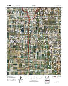
~ Derby KS topo map, 1:24000 scale, 7.5 X 7.5 Minute, Historical, 2012
Derby, Kansas, USGS topographic map dated 2012.
Includes geographic coordinates (latitude and longitude). This topographic map is suitable for hiking, camping, and exploring, or framing it as a wall map.
Printed on-demand using high resolution imagery, on heavy weight and acid free paper, or alternatively on a variety of synthetic materials.
Topos available on paper, Waterproof, Poly, or Tyvek. Usually shipping rolled, unless combined with other folded maps in one order.
- Product Number: USGS-5690427
- Free digital map download (high-resolution, GeoPDF): Derby, Kansas (file size: 19 MB)
- Map Size: please refer to the dimensions of the GeoPDF map above
- Weight (paper map): ca. 55 grams
- Map Type: POD USGS Topographic Map
- Map Series: US Topo
- Map Verison: Historical
- Cell ID: 11999
- Datum: North American Datum of 1983
- Map Projection: Transverse Mercator
- Map Cell Name: Derby
- Grid size: 7.5 X 7.5 Minute
- Date on map: 2012
- Map Scale: 1:24000
- Geographical region: Kansas, United States
Neighboring Maps:
All neighboring USGS topo maps are available for sale online at a variety of scales.
Spatial coverage:
Topo map Derby, Kansas, covers the geographical area associated the following places:
- Kuhns Mobile Home Park - Derby - Twin Oaks Estates Mobile Home Park - Sherwood Acres Mobile Home Park - Lamplighter Mobile Home Park - Lakeview Mobile Home Park - River Oaks Mobile Home Park - South Seneca Gardens - Welcome Home Community Mobile Home Park - Sunview Mobile Home Park - Wego-Waco - Southborough Estates Mobile Home Park - Woodlands Mobile Home Park - Deer Lake Mobile Home Estates - Oakwood Manor Mobile Home Park - Glen Acres Mobile Home Park - Englewood Mobile Home Park - Glenville - Keeler - Silver Spur Mobile Home Park - Purcell - MacArthur Place Mobile Home Park - Riverside - Peachwood Manor Mobile Home Park - Riverside Mobile Home Park - Young Mobile Home Park - Sunset Park - Harbor Mobile Home Park - Midland - Pinaire Mobile Home Park - Connell - Cambridge Mobile Home Park - Midland Tower - Pacesetter Mobile Home Park - Wayne Smith Mobile Home Park - Caudill Mobile Home Park - Waco - Audora Mobile Home Park - Haysville - Mobile Manor Estates Mobile Home Park - El Caudillo Mobile Home Park - Park Avenue Estates Mobile Home Park - Cedar Ridge Mobile Home Park - Thompsons Mobile Home Park - Oaklawn - Mona Kay Heights - The Woodlands Mobile Home Park - Willowood Estates Mobile Home Park - Sand Burr Hill - Rolling Green Mobile Home Park - Hardison Shady Acres Mobile Home Park - Timbercreek Mobile Home Park - Midland Park - Sycamore Square Mobile Home Park - Air Capital Mobile Home Park - Conestoga Mobile Home Park
- Map Area ID: AREA37.62537.5-97.375-97.25
- Northwest corner Lat/Long code: USGSNW37.625-97.375
- Northeast corner Lat/Long code: USGSNE37.625-97.25
- Southwest corner Lat/Long code: USGSSW37.5-97.375
- Southeast corner Lat/Long code: USGSSE37.5-97.25
- Northern map edge Latitude: 37.625
- Southern map edge Latitude: 37.5
- Western map edge Longitude: -97.375
- Eastern map edge Longitude: -97.25


