
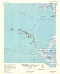
~ Point Au Fer LA topo map, 1:62500 scale, 15 X 15 Minute, Historical, 1957, updated 1957
Point Au Fer, Louisiana, USGS topographic map dated 1957.
Includes geographic coordinates (latitude and longitude). This topographic map is suitable for hiking, camping, and exploring, or framing it as a wall map.
Printed on-demand using high resolution imagery, on heavy weight and acid free paper, or alternatively on a variety of synthetic materials.
Topos available on paper, Waterproof, Poly, or Tyvek. Usually shipping rolled, unless combined with other folded maps in one order.
- Product Number: USGS-5689914
- Free digital map download (high-resolution, GeoPDF): Point Au Fer, Louisiana (file size: 5 MB)
- Map Size: please refer to the dimensions of the GeoPDF map above
- Weight (paper map): ca. 55 grams
- Map Type: POD USGS Topographic Map
- Map Series: HTMC
- Map Verison: Historical
- Cell ID: 61090
- Scan ID: 334924
- Imprint Year: 1957
- Aerial Photo Year: 1955
- Datum: NAD27
- Map Projection: Polyconic
- Map published by United States Army Corps of Engineers
- Keywords: Overedge with No Adjacent Map
- Map Language: English
- Scanner Resolution: 600 dpi
- Map Cell Name: Point au Fer
- Grid size: 15 X 15 Minute
- Date on map: 1957
- Map Scale: 1:62500
- Geographical region: Louisiana, United States
Neighboring Maps:
All neighboring USGS topo maps are available for sale online at a variety of scales.
Spatial coverage:
Topo map Point Au Fer, Louisiana, covers the geographical area associated the following places:
- Narrow Hammock - Plumb Island Pass - Little Hammock - Lake Chapeau - Little Bay - North Point - Atchafalaya Delta State Wildlife Management Area - Plumb Island - Two Oaks - Deer Island - Deer Island Bayou - Atchafalaya Bay - Turn Point - Ann Channel - Shell Island - Fox Point - Eugene Island - Alligator Cut - Plumb Island Point - Round Bayou - Plumb Island Pass - Fishing Point - Burkes Bayou - Fishing Bend - Mullet Cove - Little Bayou - Point Au Fer Shell Reef - Raquet Pass - Point Au Fer Oil Field - Locust Bayou - Lower Atchafalaya River - Dead Alligator Point - Deer Island Pass - Pount au Fer
- Map Area ID: AREA29.529.25-91.5-91.25
- Northwest corner Lat/Long code: USGSNW29.5-91.5
- Northeast corner Lat/Long code: USGSNE29.5-91.25
- Southwest corner Lat/Long code: USGSSW29.25-91.5
- Southeast corner Lat/Long code: USGSSE29.25-91.25
- Northern map edge Latitude: 29.5
- Southern map edge Latitude: 29.25
- Western map edge Longitude: -91.5
- Eastern map edge Longitude: -91.25


