
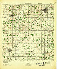
~ Bryan OH topo map, 1:62500 scale, 15 X 15 Minute, Historical, 1943
Bryan, Ohio, USGS topographic map dated 1943.
Includes geographic coordinates (latitude and longitude). This topographic map is suitable for hiking, camping, and exploring, or framing it as a wall map.
Printed on-demand using high resolution imagery, on heavy weight and acid free paper, or alternatively on a variety of synthetic materials.
Topos available on paper, Waterproof, Poly, or Tyvek. Usually shipping rolled, unless combined with other folded maps in one order.
- Product Number: USGS-5689586
- Free digital map download (high-resolution, GeoPDF): Bryan, Ohio (file size: 8 MB)
- Map Size: please refer to the dimensions of the GeoPDF map above
- Weight (paper map): ca. 55 grams
- Map Type: POD USGS Topographic Map
- Map Series: HTMC
- Map Verison: Historical
- Cell ID: 396088
- Scan ID: 224212
- Woodland Tint: Yes
- Datum: NAD
- Map Projection: Polyconic
- Map published by United States Army Corps of Engineers
- Map published by United States Department of War
- Map Language: English
- Scanner Resolution: 600 dpi
- Map Cell Name: Bryan
- Grid size: 15 X 15 Minute
- Date on map: 1943
- Map Scale: 1:62500
- Geographical region: Ohio, United States
Neighboring Maps:
All neighboring USGS topo maps are available for sale online at a variety of scales.
Spatial coverage:
Topo map Bryan, Ohio, covers the geographical area associated the following places:
- Willow Glenn - Edgerton - Bona Vista - McDonald Subdivision - Hutchison's Mobile Home Park - Rachel Heights - Norlick Place - Mina - Jerrys First Addition - Bona Vesta - Denmark (historical) - The Bend - Farmer - Clarksville (historical) - Sinns Subdivision - Krohns Acres - Bryan - El Grande Estates - Sherwood - Tree Meadows Mobile Home Park - Durham Estates - Moats - Bryan Mobile Home Park - Logan - Cicero (historical) - Valley Springs Addition - Ney - Lawtonville (historical) - Freedom (historical) - Plover Lake Addition - Rosedale - Oak Meadows - Melbern - Hicksville - Six Corners - Wilseyville (historical) - Pleasant Meadows - Holly Addition - Beverly Trailer Park - Mark Center - Williams Center
- Map Area ID: AREA41.541.25-84.8041667-84.5
- Northwest corner Lat/Long code: USGSNW41.5-84.8041667
- Northeast corner Lat/Long code: USGSNE41.5-84.5
- Southwest corner Lat/Long code: USGSSW41.25-84.8041667
- Southeast corner Lat/Long code: USGSSE41.25-84.5
- Northern map edge Latitude: 41.5
- Southern map edge Latitude: 41.25
- Western map edge Longitude: -84.8041667
- Eastern map edge Longitude: -84.5


