
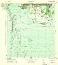
~ Pass A Grille FL topo map, 1:31680 scale, 7.5 X 7.5 Minute, Historical, 1943
Pass A Grille, Florida, USGS topographic map dated 1943.
Includes geographic coordinates (latitude and longitude). This topographic map is suitable for hiking, camping, and exploring, or framing it as a wall map.
Printed on-demand using high resolution imagery, on heavy weight and acid free paper, or alternatively on a variety of synthetic materials.
Topos available on paper, Waterproof, Poly, or Tyvek. Usually shipping rolled, unless combined with other folded maps in one order.
- Product Number: USGS-5689130
- Free digital map download (high-resolution, GeoPDF): Pass A Grille, Florida (file size: 5 MB)
- Map Size: please refer to the dimensions of the GeoPDF map above
- Weight (paper map): ca. 55 grams
- Map Type: POD USGS Topographic Map
- Map Series: HTMC
- Map Verison: Historical
- Cell ID: 34358
- Scan ID: 348033
- Woodland Tint: Yes
- Datum: NAD27
- Map Projection: Polyconic
- Map published by United States Army Corps of Engineers
- Map published by United States Department of War
- Keywords: Overedge with No Adjacent Map
- Map Language: English
- Scanner Resolution: 600 dpi
- Map Cell Name: Pass-a-Grille Beach
- Grid size: 7.5 X 7.5 Minute
- Date on map: 1943
- Map Scale: 1:31680
- Geographical region: Florida, United States
Neighboring Maps:
All neighboring USGS topo maps are available for sale online at a variety of scales.
Spatial coverage:
Topo map Pass A Grille, Florida, covers the geographical area associated the following places:
- Don Ce-Sar Place (historical) - Tierra Verde - Belle Vista Beach (historical) - Bayway - Lakewood Estates - Bahia Shores - Saint Pete Beach - Gulfport - Point Brittany - Broadwater
- Map Area ID: AREA27.7527.625-82.75-82.625
- Northwest corner Lat/Long code: USGSNW27.75-82.75
- Northeast corner Lat/Long code: USGSNE27.75-82.625
- Southwest corner Lat/Long code: USGSSW27.625-82.75
- Southeast corner Lat/Long code: USGSSE27.625-82.625
- Northern map edge Latitude: 27.75
- Southern map edge Latitude: 27.625
- Western map edge Longitude: -82.75
- Eastern map edge Longitude: -82.625


