
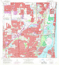
~ North Miami FL topo map, 1:24000 scale, 7.5 X 7.5 Minute, Historical, 1962, updated 1971
North Miami, Florida, USGS topographic map dated 1962.
Includes geographic coordinates (latitude and longitude). This topographic map is suitable for hiking, camping, and exploring, or framing it as a wall map.
Printed on-demand using high resolution imagery, on heavy weight and acid free paper, or alternatively on a variety of synthetic materials.
Topos available on paper, Waterproof, Poly, or Tyvek. Usually shipping rolled, unless combined with other folded maps in one order.
- Product Number: USGS-5689112
- Free digital map download (high-resolution, GeoPDF): North Miami, Florida (file size: 17 MB)
- Map Size: please refer to the dimensions of the GeoPDF map above
- Weight (paper map): ca. 55 grams
- Map Type: POD USGS Topographic Map
- Map Series: HTMC
- Map Verison: Historical
- Cell ID: 32400
- Scan ID: 347687
- Imprint Year: 1971
- Woodland Tint: Yes
- Photo Revision Year: 1969
- Aerial Photo Year: 1969
- Field Check Year: 1962
- Survey Year: 1939
- Datum: NAD27
- Map Projection: Polyconic
- Map published by United States Geological Survey
- Map published by United States Department of Commerce
- Keywords: Overedge with No Adjacent Map
- Map Language: English
- Scanner Resolution: 600 dpi
- Map Cell Name: North Miami
- Grid size: 7.5 X 7.5 Minute
- Date on map: 1962
- Map Scale: 1:24000
- Geographical region: Florida, United States
Neighboring Maps:
All neighboring USGS topo maps are available for sale online at a variety of scales.
Spatial coverage:
Topo map North Miami, Florida, covers the geographical area associated the following places:
- S S Mobile Park - Coes Trailer Court - Indian Creek Village - Dixie Mobile Court - Sun Swept Isles - Andover Golf Estates - Pembroke Park - Hallandale Beach - Golden Glades - Golden Trio Mobile Home Park - Royal Palm Mobile Home Park - Miami Gardens - Bunche Park - Nelson Mobile Home Park - Lone Pines Mobile Village - Sanders Mobile Home Colony - Home Mobile Home Park - Green Acres Mobile Home Village - Holiday Mobile Estates - Scott Lake - Courtly Manor - Adirondack Trailer Park - Mitchell Lake Estates - North Miami Beach - Surfside - Shady Oaks Trailer Park - Coes Trailer Park - Snowbird Haven Mobile Home Park - Lake Forest - Ro-Len Lake Gardens - Landmark Mobile Home Park - Kobe Trailer Court - Biscayne Park - Carol City - La Siesta Mobile Home Park - Shady Oaks Mobile Home Park - Interama - Mickey's Mobile Home Park - Pembroke Park Lakes Mobile Home Park - Emerald Isles East Mobile Home Park - Lake Lucerne - Sun Haven of Aventura - Biscayne Breeze Park Mobile Home Park - Myricks Trailer Park - Dale Village Mobile Home Park - Gulfstream Trailer Park - Eastwood Mobile Home Park - Biscayne Gardens - Highland Lakes - Golden Shores - Andover Lakes Estates - San Souci Estates - Aventura - Carver Ranches - Golden Isles - Tower Mobile Home Park - Palm Trailer Park - Hollywood Mobile Estates - Miami Gardens - Lone Pine Mobile Home Park West - Eastern Shores - Keystone Islands - Bamboo Lakes Trailer Park - Hi Land Trailer Court - Sea Estates Mobile Home Court - La Palm Trailer Park - Ives Estates - Sixth Avenue Trailer Park - Hollywood Ridge Farms - Andover - Utopia - West Park - North Miami Trailer Park - North Miami - Miramar - Bay Harbor Islands - Norland - Palm Trailer Park - Bal Harbour - Orange Brook Mobile Home Estates - El Rancho Trailer Park - Sixth Avenue Trailer Park - Ojus - Westview - Woodbine Mobile Home Park
- Map Area ID: AREA2625.875-80.25-80.125
- Northwest corner Lat/Long code: USGSNW26-80.25
- Northeast corner Lat/Long code: USGSNE26-80.125
- Southwest corner Lat/Long code: USGSSW25.875-80.25
- Southeast corner Lat/Long code: USGSSE25.875-80.125
- Northern map edge Latitude: 26
- Southern map edge Latitude: 25.875
- Western map edge Longitude: -80.25
- Eastern map edge Longitude: -80.125


