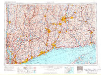
~ Hartford CT topo map, 1:250000 scale, 1 X 2 Degree, Historical, 1965, updated 1965
Hartford, Connecticut, USGS topographic map dated 1965.
Includes geographic coordinates (latitude and longitude). This topographic map is suitable for hiking, camping, and exploring, or framing it as a wall map.
Printed on-demand using high resolution imagery, on heavy weight and acid free paper, or alternatively on a variety of synthetic materials.
Topos available on paper, Waterproof, Poly, or Tyvek. Usually shipping rolled, unless combined with other folded maps in one order.
- Product Number: USGS-5688600
- Free digital map download (high-resolution, GeoPDF): Hartford, Connecticut (file size: 22 MB)
- Map Size: please refer to the dimensions of the GeoPDF map above
- Weight (paper map): ca. 55 grams
- Map Type: POD USGS Topographic Map
- Map Series: HTMC
- Map Verison: Historical
- Cell ID: 72228
- Scan ID: 461617
- Imprint Year: 1965
- Field Check Year: 1962
- Datum: Unstated
- Map Projection: Transverse Mercator
- Map published by United States Geological Survey
- Map published by United States Army Corps of Engineers
- Map published by United States Army
- Map Language: English
- Scanner Resolution: 600 dpi
- Map Cell Name: Hartford
- Grid size: 1 X 2 Degree
- Date on map: 1965
- Map Scale: 1:250000
- Geographical region: Connecticut, United States
Neighboring Maps:
All neighboring USGS topo maps are available for sale online at a variety of scales.
Spatial coverage:
Topo map Hartford, Connecticut, covers the geographical area associated the following places:
- Crystal Lake - Kent - Bedford Center - Overlook - Sharon - Sherman Park - Haines Corners - Higley Village - South Wethersfield - Avon Park South - Quinnipiac - Romford - Berkshire - New City - Straitsville - Jericho - Hoxie Corner - Towners - Sharon Station - Scarsdale - Enfield - Forestville - Steinbeck Corners - Bayview - Orangeburg - Chimney Point - Natchaug (historical) - Bakersville - Silver Beach - Granbrook Park - Katonah - Parkville - Highwood (historical) - Fishers Island - Burnside - Pine Meadow - Hydeville - Mount Pleasant Housing - Brownsell Corner - Atwoodville - East White Plains - Hawleyville - Erickson Corner - Port Chester - Lake Katonah - Rhinebeck Manor Mobile Home Park - Rye Brook - Cos Cob - New Preston - Hollywyle Park - Stillwater - Hayden - Millerton - Woodville - Aqua Vista - Milldale - Knolls Trailer Court - Guilford - Lakeridge Heights - Southold - Cromwell - East Cornwall - Ives Corner - West Hartford - High Ridge - Birchwood Park - Easton - West Patterson - Oakes - Ennis Mobile Home Park - The Gables - Sunnyside Trailer Park - Groton Long Point - Godfrey Corner - Irvington - Newfield Heights - Strathmore Woods - Hillside Lake - Buckingham - Cheshire - Mianus - Turkey Cobble - Cooper Road Mobile Home Park - West Haverstraw - Philipse Manor - Lanesville - West Hill - Marlborough - Brooksvale - Spoonville (historical) - Windmill Farm - East Wallingford - M And K Mobile Home Park - Daniels Mill - Gaylordsville - East Hampton - Winnipauk Village - Pleasant Acres - Oxford Village - Dingle
- Map Area ID: AREA4241-74-72
- Northwest corner Lat/Long code: USGSNW42-74
- Northeast corner Lat/Long code: USGSNE42-72
- Southwest corner Lat/Long code: USGSSW41-74
- Southeast corner Lat/Long code: USGSSE41-72
- Northern map edge Latitude: 42
- Southern map edge Latitude: 41
- Western map edge Longitude: -74
- Eastern map edge Longitude: -72