
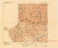
~ Big Bar and Vicinity CA topo map, 1:250000 scale, 30 X 30 Minute, Historical, 1915, updated 1948
Big Bar and Vicinity, California, USGS topographic map dated 1915.
Includes geographic coordinates (latitude and longitude). This topographic map is suitable for hiking, camping, and exploring, or framing it as a wall map.
Printed on-demand using high resolution imagery, on heavy weight and acid free paper, or alternatively on a variety of synthetic materials.
Topos available on paper, Waterproof, Poly, or Tyvek. Usually shipping rolled, unless combined with other folded maps in one order.
- Product Number: USGS-5688422
- Free digital map download (high-resolution, GeoPDF): Big Bar and Vicinity, California (file size: 4 MB)
- Map Size: please refer to the dimensions of the GeoPDF map above
- Weight (paper map): ca. 55 grams
- Map Type: POD USGS Topographic Map
- Map Series: HTMC
- Map Verison: Historical
- Cell ID: 396076
- Scan ID: 299743
- Imprint Year: 1948
- Survey Year: 1911
- Datum: NAD
- Map Projection: Polyconic
- Map published by United States Geological Survey
- Map Language: English
- Scanner Resolution: 600 dpi
- Map Cell Name: Big Bar And Vicinity
- Grid size: 30 X 30 Minute
- Date on map: 1915
- Map Scale: 1:250000
- Geographical region: California, United States
Neighboring Maps:
All neighboring USGS topo maps are available for sale online at a variety of scales.
Spatial coverage:
Topo map Big Bar and Vicinity, California, covers the geographical area associated the following places:
- Hyampom - Denny - Burnt Ranch - Trinity Village - Salyer - Hayfork - Willow Creek - Janes Place - Dinsmores - Junction City - Wigdon Place - Luckie Place - Big Bar - Globe Mill - Hoboken - Dedrick - Quinby - Hawkins Bar - Helena - Del Loma
- Map Area ID: AREA4140.5-123.75-123
- Northwest corner Lat/Long code: USGSNW41-123.75
- Northeast corner Lat/Long code: USGSNE41-123
- Southwest corner Lat/Long code: USGSSW40.5-123.75
- Southeast corner Lat/Long code: USGSSE40.5-123
- Northern map edge Latitude: 41
- Southern map edge Latitude: 40.5
- Western map edge Longitude: -123.75
- Eastern map edge Longitude: -123


