
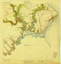
~ Seabrook TX topo map, 1:31680 scale, 7.5 X 7.5 Minute, Historical, 1920
Seabrook, Texas, USGS topographic map dated 1920.
Includes geographic coordinates (latitude and longitude). This topographic map is suitable for hiking, camping, and exploring, or framing it as a wall map.
Printed on-demand using high resolution imagery, on heavy weight and acid free paper, or alternatively on a variety of synthetic materials.
Topos available on paper, Waterproof, Poly, or Tyvek. Usually shipping rolled, unless combined with other folded maps in one order.
- Product Number: USGS-5686783
- Free digital map download (high-resolution, GeoPDF): Seabrook, Texas (file size: 7 MB)
- Map Size: please refer to the dimensions of the GeoPDF map above
- Weight (paper map): ca. 55 grams
- Map Type: POD USGS Topographic Map
- Map Series: HTMC
- Map Verison: Historical
- Cell ID: 25229
- Scan ID: 128302
- Woodland Tint: Yes
- Visual Version Number: 1
- Survey Year: 1916
- Datum: Unstated
- Map Projection: Unstated
- Map published by United States Geological Survey
- Keywords: Overedge with No Adjacent Map
- Map Language: English
- Scanner Resolution: 600 dpi
- Map Cell Name: League City
- Grid size: 7.5 X 7.5 Minute
- Date on map: 1920
- Map Scale: 1:31680
- Geographical region: Texas, United States
Neighboring Maps:
All neighboring USGS topo maps are available for sale online at a variety of scales.
Spatial coverage:
Topo map Seabrook, Texas, covers the geographical area associated the following places:
- Webster - Clear Creek Crossing - Meadow Bend - South Shore Village - Lakeside - Bay Breeze - Bay Ridge - Lazy Bend - Clear Lake Shores - Clear Lake City - Shady Oaks - Seabrook - League City - Todville - Seagate - Bayview - Rancho Del Rey Mobile Home Park - Taylor Lake Village - Middlebrook - Foster Place - Kemah - Mystic Village - University Green - Brookwood - Nassau Bay - Baybrook - Gateway Village - University Park - Briar Glen - El Lago - Shoreacres - Kemah Park - Kilkare (historical) - Glen Cove
- Map Area ID: AREA29.62529.5-95.125-95
- Northwest corner Lat/Long code: USGSNW29.625-95.125
- Northeast corner Lat/Long code: USGSNE29.625-95
- Southwest corner Lat/Long code: USGSSW29.5-95.125
- Southeast corner Lat/Long code: USGSSE29.5-95
- Northern map edge Latitude: 29.625
- Southern map edge Latitude: 29.5
- Western map edge Longitude: -95.125
- Eastern map edge Longitude: -95


