
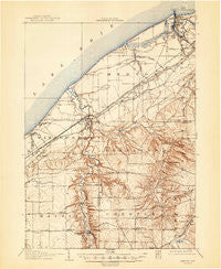
~ Mentor OH topo map, 1:62500 scale, 15 X 15 Minute, Historical, 1907, updated 1947
Mentor, Ohio, USGS topographic map dated 1907.
Includes geographic coordinates (latitude and longitude). This topographic map is suitable for hiking, camping, and exploring, or framing it as a wall map.
Printed on-demand using high resolution imagery, on heavy weight and acid free paper, or alternatively on a variety of synthetic materials.
Topos available on paper, Waterproof, Poly, or Tyvek. Usually shipping rolled, unless combined with other folded maps in one order.
- Product Number: USGS-5686309
- Free digital map download (high-resolution, GeoPDF): Mentor, Ohio (file size: 8 MB)
- Map Size: please refer to the dimensions of the GeoPDF map above
- Weight (paper map): ca. 55 grams
- Map Type: POD USGS Topographic Map
- Map Series: HTMC
- Map Verison: Historical
- Cell ID: 57524
- Scan ID: 227852
- Imprint Year: 1947
- Survey Year: 1905
- Datum: NAD
- Map Projection: Polyconic
- Map published by United States Geological Survey
- Keywords: Overedge with No Adjacent Map
- Map Language: English
- Scanner Resolution: 600 dpi
- Map Cell Name: Mentor
- Grid size: 15 X 15 Minute
- Date on map: 1907
- Map Scale: 1:62500
- Geographical region: Ohio, United States
Neighboring Maps:
All neighboring USGS topo maps are available for sale online at a variety of scales.
Spatial coverage:
Topo map Mentor, Ohio, covers the geographical area associated the following places:
- Johnson Mobile Home Park - Fairgrounds Mobile Home Park - Brentwood - Chester Center - Eastlake - Will-O-Bee on the Lake - Willoughbeach - Concord Estates - Chesterland - Grand River - Pleasant Valley - Willoughby - Orchard Grove - Highland Heights - Mentor Green Mobile Home Park - M And K Trailer Park - Kirtland - Mentor Headlands - Arrowhead Beach - Mentor - Chagrin Harbor - Will-O-Wick - Rush Road (historical) - Hach's Mobile Home Park - Mentor Acres - Fowlers Mill - Reynolds - Lakeline - Chargin Harbor Beach - Wilder Senior Citizen Mobile Home Park South - West Mentor - Lyndhurst - North Munson - Mentor-on-the-Lake - Kirtland Mobile Home Park - Pecks Corners - Wilder Senior Citizen Mobile Home Park North - Orchard Mobile Home Park - Brookwood Beach - Mayfield - Little Mountain - Eagle Trailer Park - Driftwood - Heisley (historical) - Salida Beach - Erie Side - Willoughby Hills - Vinewood Beach - Will-O-Way Beach - Mountain View - West Walnut Estates - Oak Hill Village - Willowick - Scotland - Waite Hill - Gates Mills - Avenues Mobile Estates - Timberlake - Parks Corner - Courtyard Mobile Home Park - Salida - Mayfield Heights - Kirtland Hills - Wickliffe - South Church
- Map Area ID: AREA41.7541.5-81.5-81.25
- Northwest corner Lat/Long code: USGSNW41.75-81.5
- Northeast corner Lat/Long code: USGSNE41.75-81.25
- Southwest corner Lat/Long code: USGSSW41.5-81.5
- Southeast corner Lat/Long code: USGSSE41.5-81.25
- Northern map edge Latitude: 41.75
- Southern map edge Latitude: 41.5
- Western map edge Longitude: -81.5
- Eastern map edge Longitude: -81.25


