
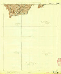
~ Bryson NC topo map, 1:62500 scale, 15 X 15 Minute, Historical, 1933
Bryson, North Carolina, USGS topographic map dated 1933.
Includes geographic coordinates (latitude and longitude). This topographic map is suitable for hiking, camping, and exploring, or framing it as a wall map.
Printed on-demand using high resolution imagery, on heavy weight and acid free paper, or alternatively on a variety of synthetic materials.
Topos available on paper, Waterproof, Poly, or Tyvek. Usually shipping rolled, unless combined with other folded maps in one order.
- Product Number: USGS-5685861
- Free digital map download (high-resolution, GeoPDF): Bryson, North Carolina (file size: 4 MB)
- Map Size: please refer to the dimensions of the GeoPDF map above
- Weight (paper map): ca. 55 grams
- Map Type: POD USGS Topographic Map
- Map Series: HTMC
- Map Verison: Historical
- Cell ID: 51865
- Scan ID: 161719
- Survey Year: 1930
- Datum: Unstated
- Map Projection: Unstated
- Map Language: English
- Scanner Resolution: 600 dpi
- Map Cell Name: Bryson
- Grid size: 15 X 15 Minute
- Date on map: 1933
- Map Scale: 1:62500
- Geographical region: North Carolina, United States
Neighboring Maps:
All neighboring USGS topo maps are available for sale online at a variety of scales.
Spatial coverage:
Topo map Bryson, North Carolina, covers the geographical area associated the following places:
- Jackson Line - Bryson City - Gay - Savannah - Cowee - Dillsboro - Paint Town - Shallow Ford - Whittier - Jenkins Place - Oconaluftee Indian Village - Franklin Grove - Olivet - Indian Hills - Oak Grove - Big Laurel - Leatherman - Stiles - Greens Creek - Pumpkintown - Ela - Lackey Hill - De Hart Mill - Qualla - Wilmot - Alarka - Cherokee - Unahala - Birdtown
- Map Area ID: AREA35.535.25-83.5-83.25
- Northwest corner Lat/Long code: USGSNW35.5-83.5
- Northeast corner Lat/Long code: USGSNE35.5-83.25
- Southwest corner Lat/Long code: USGSSW35.25-83.5
- Southeast corner Lat/Long code: USGSSE35.25-83.25
- Northern map edge Latitude: 35.5
- Southern map edge Latitude: 35.25
- Western map edge Longitude: -83.5
- Eastern map edge Longitude: -83.25


